 SectionHiker.com Backpacking Gear Reviews and FAQs
Days 10-11: Braemar to Tarfside
The next few days will put my navigation skills to the test. I'll be passing over very wild, open country to get to Lochnagar, a cluster of magnificent Munros, south of the Royal Balmoral Castle and Estate. From there, I continue southeast to Tarfside past Loch Lee.
Until now, I've relied on natural features, such as rivers, as navigational aides. It's hard to get lost if you follow the bank or keep the river valley in sight. NOLS, by the way, calls these navigational land features "handrails." But in this section of my hike, I will be passing over open country and need to be on my toes and my compass bearing.
Day 10: Braemar to Glas-allt Shiel


Leave Braemar, heading east past Hotel Castelton. Walking along the south of Creag Choinnich (NO160919), which overlooks the town, past the Lions Face (mile 1) to an old military road (NO169917). From here, head east along the road or in the woods to the south side of Invercauld Bridge (NO185908). There is no need to cross it. Stay to the south. Continue east, walking along the south side of the Dee along single tracks and jeep paths to Connachat Cottage (NO216918, 4.5 miles.) Pick up a jeep track headed southeast at NO220919. This track passes between through the woods at Moine Chruinn and runs between Ripe Hill and Cnap a Coire Bhuidhe, intersecting a stream at NO237903, mile 6.3.
Follow the land rover track to the north of the stream, heading east to Geldie Burn (NO250908) and then head south. Follow another jeep track past Gelder Shiel at mile 8 (NO257889.) Pass Gelder Shiel, following the single track southeast to the base of Little Conachcraig at mile 9 and NO269889. Meet up with a jeep track and head south past Caisteal na Callich (862m) and Connach Craig (850m) which will be east of the track. Coire na Ciche will be to the west. Lochnagar should ahead to the southwest.
From this point, there are a number of options. After a short 11 mile day, I can camp at the base of Meilke Pap and the head of Coire na Ciche (NO273869). The elevation is 700 meters and water is available down the jeep track in about a quarter of a mile at Clais Rathadan. If it is raining, very windy, or the peaks of Lochnagar are covered in cloud, I may decide to stop to climb Meikle Pap on the next day. If the weather will be miserable the next day (I'm carrying a barometer) and there is no hope of climbing Meikle Pap, my foul weather bypass is to continue south down the single track below Little Pap (950m) via Monelpie Moss and Glass-Allt to the bothy at Glas-alt Shiel on Lock Muick.
Here's what I going to write on my route sheet for the second half of Day 10:
Coire na Ciche, Clais Rathadan, Meikle Pap, Clais Rathadan, Monelpie Moss, Glas-Allt to Glass-Allt Shiel with a foul weather option of Coire na Ciche, Clais Rathadan, Monelpie Moss, Glas-Allt to Glass-Allt Shiel. You can see this on the thumbnail map fragments above.
As an aside, this is a major cut down from the five munros I wanted to climb at Lochnagar before I started detailed route planning. I'd credit my planning for making me really pay attention to the contour lines and figuring out what parts of Lochnagar are most interesting to climb in a one day drive by. I now have a much more realistic plan that is also lower risk and more achievable. Time permitting, I may explore some additional munros in the area.
Day 11: Glas-allt Shiel to Tarfside

I set out form the Glas-allt Shiel bothy (where I plan on camping outside), along Lock Muick headed northeast along the shore. Behind me Lochnagar rises very steeply from the shore. At the boathouse near mile 2, I turn southeast again and cross the mouth of Lock Muick over a bridge at NO299841.
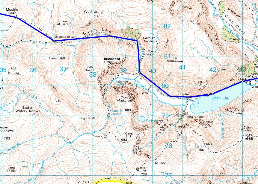
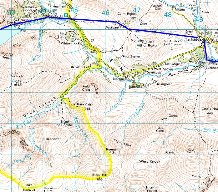
After crossing the bridge, I'll take a compass bearing and head overland to the bothy at Sheilin of Mark (NO336826), followed by Muckle Cairn (NO354822), and the Stables of Lee (NO366815) at mile 6.8. From there, I pick up a jeep track that runs along the Water of Lee through Glen Lee (NO384817) and follows the northern shore of Loch Lee, passing the ruins of Invermark Castle.
From here, I continue on a straight southeast bearing, crossing a small road, then along a jeep track to the Hill of Rowan and down to Tarfside at mile 15.27.
Hi Philip,
Route looks great!
I've submitted the Glen Calleter route to Lochnager and Glas-allt-Shiel, so might see you there or on the hill. Hoping for good weather and a lot of snow melt between now and then.
Michael
Michael – my original plans called for a lot more tops at Lochnagar. If the weather is clear, I still plan on bagging a few more rather than just the drive by that I have on the route now. I hadn't counted on snow, but it shouldn't matter unless an axe is required. Hope to see you up there or down by the bothy.
Phillip, while I'm at it, while researching the walking around Lochnager, I came across an interesting and entertaining account of the area dating from the 1890's: LOCHNAGAR BY ALEX. INKSON M^CONNOCHIE https://www.archive.org/stream/lochnagar00mccogoog…
In it, there are descriptions of the tracks and scenery of the area including things that are on the current maps but unnamed, (and things that have been renamed) along with accounts of events around and on the mountain in that era.
Regards, Michael
When ye White Mounth frae snaw is clear,
Ye day o' doom is drawin* near.
very cool link – I've got to read this!