 SectionHiker.com Backpacking Gear Reviews and FAQs
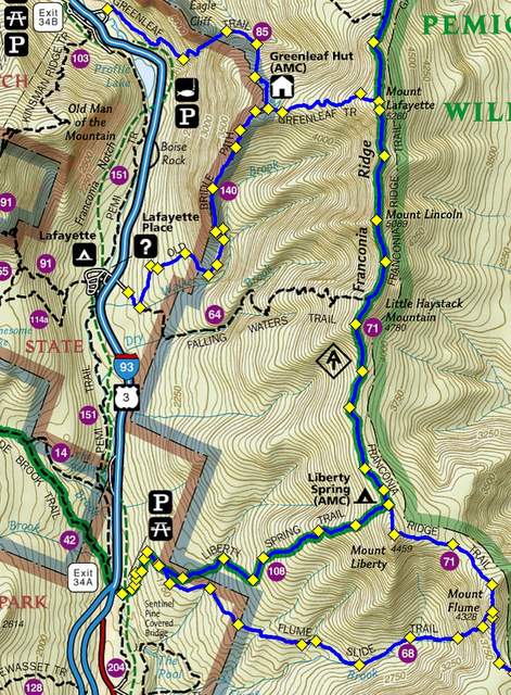
The Franconia Ridge Traverse is one of the most magnificent hikes in New Hampshire’s White Mountains and one that I never get tired of hiking. Located in Franconia Notch, the route involves climbing four 4000 footers: Mt Flume (4328′), Mt Liberty (4459′), Mt Lincoln (5089′), and Mt Lafayette (5260′) by the Franconia Ridge Trail, which runs north to south between Flume and Lafayette.
Once you’re on the ridge, the hiking is fairly easy provided you have clear skies, warm temperatures, and little wind. But those days are far and few between which ups the difficulty and potential peril of this hike. Having climbed these peaks in winter, spring, summer, and fall, in white-outs and winter cold, makes me appreciate those blue bird days even more because I can take my time hiking along the ridge and enjoy long breaks to admire the awesome views from its rocky ledges.
The hard part of a Franconia Ridge Traverse is getting up to the ridge because it involves several thousand feet of elevation gain over very challenging and rocky trails. Doing all the peaks in one day can also be challenging because a full traverse makes a very long loop hike (about 16 miles) or requires multiple car spots at the beginning and end of your route. It’s also possible to hike Mt Lafayette and Mt Lincoln as a loop (see the Franconia Loop), and leave Liberty and Flume for another day, which many people do.

Approach Trails
When planning a full traverse, you need to decide whether you’re going to hike it from north to south (Lafayette, Lincoln, Liberty, and Flume) or south to north (Flume, Liberty, Lincoln, and Lafayette).
The advantage of hiking from north to south is that you get most of the elevation for the hike out-of-the-way up front and that you can stop at the AMC Greenleaf hut on the way to Lafayette (when the hut is open) and get out of the weather, eat some food, and refill your water bottles before you commit to climbing the peak. Lafayette is the hardest mountain to climb on the route and can be quite dangerous in bad weather because the route to the summit is completely exposed.
The advantage of climbing from south to north is that the route is protected from bad weather by tree cover until just before Mt Lincoln, giving you the option to climb Mt Flume and Mt Liberty in less than perfect weather, before committing to hike Lincoln and Lafayette which are above-treeline peaks. Water is also available from a spring just three tenths of a mile below the Liberty summit, so you can refill your water bottles before heading above treeline.
All of the trails listed below can be used to descend from Franconia Ridge except the Flume Slide Trail, which is considered too dangerous and should only be used for ascents.

North to South Approach Trails
If you decide to hike from north to south, there are three trails that you can use to climb Mt Lafayette:
- The most popular route is up the Old Bridle Path, a challenging and rocky trail, which leaves from a parking lot just off Interstate-93 in Franconia Notch. This route passes by the AMC Greenleaf hut.
- Hikers can also climb the Greenleaf Trail from Franconia Notch which begins near the Mt Cannon Tramway. The Greenleaf Trail is a beautiful but little used trail, which used to be the main route hikers climb to the AMC Greenleaf Hut. This route also passes by the AMC Greenleaf hut.
- The third trail to climb Lafayette is the Garfield Ridge Trail which approaches the mountain from the north and is mostly used by backpackers. This route also requires climbing northwest Lafayette, a sub-peak of the larger mountain, which can be seen from the Greenleaf Hut.

South to North Approach Trails
If you decide to hike from the south to the north, there are three trails you can use to hike to the beginning of the Franconia Ridge Trail, which starts about 0.1 miles south of the Mt Flume summit.
- The Osseo Trail is the easiest route, but starts 5.5 miles away in the Lincoln Woods parking lot off the Kancamagus Highway. The Franconia Ridge Trail begins at the end of the Osseo Trail where it intersects with the Flume Slide Trail.
- Hikers can also climb the Liberty Spring Trail which starts from the Franconia Notch Bike Path. This is a good option for solo hikers because you can follow the bike path, which is very fast walking, back to your car after descending from Lafayette or lock a bike near Lafayette and ride it back to your car. If you climb Liberty first, you do however need to hike south to Flume, turn around and reclimb Liberty if you want to hike the full traverse. This is not a hard hike, but the out and back adds another 2.4 miles to the route.
- The Flume Slide Tail is a third option but not recommended because the trail climbs steeply up wet rock slabs and is very time-consuming to climb.

Walking the Franconia Ridge Trail
The Franconia Ridge Trail can be broken into two logical sections, the section below treeline and the section above treeline. Treeline or the alpine zone, as it’s called in the White Mountains, starts when the trees drop below 8 feet in height. That’s the point where trees and shrubs are referred to as krummholz. This typically occurs somewhere between 4000 feet and 4500 feet of elevation in the White Mountains, but can vary between mountains.
If you’re hiking from south to north, the first peak you’ll come to is Mt Flume. Flume has a rocky summit which peaks above the trees at the last-minute, but which protected by trees to the north and south. There are some good places to sit at the top of Flume and take in the view if you feel like a short break.

Mt Liberty is 1.2 miles to the north and the trail between the two peaks descends to a low point called a col before climbing up to Liberty’s summit. Like Flume, Liberty’s rocky summit barely peaks above treeline, before dropping back under the cover of forest. There’s a bit of a scramble before and after the summit, but nothing too strenuous.
Proceeding 0.3 miles north, you’ll come to the intersection of the Liberty Spring Trail. If you’re low on water, there’s a spring 0.3 miles (5 minutes) downhill where you can refill your water bottles. The rest of the Franconia Ridge Trail is dry, and it’s best to carry a little extra water (at least 2 liters) with you for the remainder of the hike.
Continuing north along the Franconia Ridge Trail, the trail winds through dense green shrubbery and weather-scoured trees. These hide the edges of the ridge to the east and west, although you can catch vast views occasionally between their branches.

After nearly 2 miles, you come the summit to another 4000 foot mountain called Little Haystack (4780′). It’s not on the 4000 footer list but you still need to climb up and over it to get to Mt Lincoln, which is 1.2 miles further north. While the summit of Little Haystack just barely peaks above treeline, the trail after it is bare rock, fully exposed without any wind breaks.

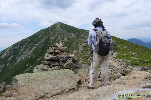
Once past Little Haystack and above treeline, you’ll see low rock walls marking the sides of the trail. It’s important that you stay between them as you walk down the ridge, because it protects the fragile plants that grow on either side. These plants are very rare and have an extremely short growing season since Franconia Ridge is covered with snow almost ten months of the year. It’s not unusual for 500 people to climb the ridge on the same day in good weather, but it only takes one person to trample these plants to death. Be a good steward, stay on the trail, and encourage others to do the same.
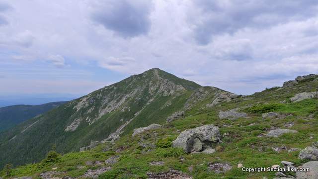
As you continue north, the perfect pyramid of Mt Lincoln will soon become visible. Over 5,000 feet in height, the front of the mountain is scarred by avalanche paths and rock falls.

Mt Lafayette is visible from the summit of Mt Lincoln, as well as a heap of stone that lies between them. Although you won’t find its name on any maps, this rock pile is known as Mt Truman or sometimes North Lincoln.
While Lafayette is somewhat similar in shape to Lincoln, you can tell the peaks apart because Lafayette has a ridge running down its west face and Lincoln doesn’t. Lafayette is also a much large mountain although you can’t really see that until you arrive on its rocky summit.

The tallest peak on Franconia Ridge, the summit of Lafayette is often crowded during the summer months because so many people climb it by itself, rather than hiking the entire ridge trail. The AMC frequently staffs the summit with a naturalist who answers visitor questions and tries to keep hikers from trampling the sensitive plans growing along the mountain’s fringe.
While the Franconia Ridge Trail ends at the summit of Mt Lafayette, it will still take you another 3-4 hours to descend to Franconia Notch. The most popular route follows the Old Bridle Path past the AMC Greenleaf Hut where you can refill your water bottles (even if you’re not an overnight guest) and purchase a snack. There are also bathrooms that are open to the public.

The trail from the summit of Lafayette to the Greenleaf Hut is quite rough and rocky so you should take your time walking down it. The path can be difficult to follow in poor visibility, so save plenty of daylight for this part of your hike to ensure that you get back down to Franconia Notch before sunset.

Once you’ve passed the hut, the Old Bridle Path drops steeply plunging down to Franconia Notch below. There are several excellent viewpoints on the way down however, so take a rest and look back up to Lafayette and Lincoln and the ravines which run down from their summits. This view can only be seen from the Old Bridle Path and not from Franconia Notch below, so savor it before continuing with your descent down to the notch.
The Old Bridle Path ends at the Falling Waters Trailhead and parking lot off Interstate 93, If to need to get back to a car parked further south, at the Basin or Flume Visitor Center parking lots, for instance, you can follow the paved Franconia Notch Bike Path back to your car. Cross under I-93 to Lafayette Place through the pedestrian tunnel and walk left pass the Hiker Information building to the Lafayette Place parking lot. The bike trail starts at the southern end of the parking lot and can be followed several miles back to your vehicle.
While the total distance of this hike will vary depending on the route you’ve chosen, hiking a complete Franconia Ridge Traverse takes most people all day to complete. When planning a hike of this magnitude make sure you start early enough in the day and descend completely before sunset, even if it means starting your climb before dawn.
It’s a great hike, but one I only do at selective times. It’s proximity to I-93 makes it very popular and is way too crowded in good weather. I’d go so far as to say overcrowded. I’ve been up there when it’s been a virtual superhighway of people. Not my idea of a nice hiking experience and certainly not good for the environment. But the state promotes it as a tourist attraction, so that’s what you get. Don’t get me wrong, this is one of the most spectacular ridge walks / hikes in the Whites, but sometimes I wish it were less accessible.
I agree. That’s why I hike these peaks on weekdays and in winter. The last time I was up there, just a few weeks ago, people (the naturalist at Grennleaf said 600 people) were crawling all over the fragile plants off trail outside the scree walls. You;ll note that I mention this in the article above…hoping it will sink in with the people who’ll read this post and want to hike the route. If we want this treasure to survuive, we need to tread lightly on those little plants and stay on the trails.
I did the short loop last summer, up Falling Waters, across from Little Haystack to Lafayette, down Greenleaf to the hut, and then Old Bridle path back to the trailhead. It was a gorgeous hike on an equally beautiful day.
I did learn that the New England definition of the adjectives used in the phrase “the trail is steep and rocky” is orders of magnitude greater than that employed in western descriptions. These old legs that hauled Grandpa down and up the Grand Canyon, across many passes in Glacier, through the Bob Marshall Wilderness, Big Bend, the Bruce Trail in Ontario, Colorado, Arkansas, Virginia, North Carolina and countless other hikes, completely rebelled after the Franconia Loop. I’d planned a Presidential traverse for later that week, but my quivering quads said, “You, and what helicopter?”
I think I need a T shirt reading:
“I got my butt kicked on Falling Waters”
How was the hike? The trail looks steep and there are too much rocks, but I bet even though it’s tiring, you still enjoy the hike. Right? Especially when you reached your destination.
yes, the effort is well worth it.
I was just saying to my friend yesterday that this is one of the great hikes in the United States. It’s really a treasure.
I’ve even come to terms with the crowds. The only way to see these views is through hard work and the people up there are putting in the work. That said, it’s appalling for people to trample the vegetation. It’s pretty clearly marked and there is just no reason to get off the trail.
I’ve done all 5 peaks, but never at the same time. I never thought to use the bike path and make this a loop.
I just make a point to get up there early in the morning.:-) That bike path is a gem. You can hike it in the dark very quickly. I’ve used it twice for doing a south to north loop.
Any experience in backcountry camping somewhere along the trail or is Liberty Spring tentsite and Greenleaf Hut the only viable options? This seems like a nice two day hike for me and my fairly inexperienced crew of born-agains
Those are really the only two options unless you go down the back side of Lincoln and I really wouldn’t recommend that if you’re not an expert off-trail hiker. The problem is water and the extreme slope gradient.
@Eric r- my daughter and I camped below tree line on the short loop. U need to be off trail 200 feet. Night one we found a great flat site, night two we barely got below tree line. It was rainy and cold. We tented on a slanted boulder in the woods- ,not a great night, but a story nevertheless. Beware of bears and be prepared to cook away from your site and hang your food.
This is the only hike I’ve done in the east and it was beautiful. It wasn’t crowded at all as the ridge tops were covered in clouds and it was very windy. I hope to get back there and do it again sometime.
I traversed the ridge last summer on a modified Pemi loop and saw one other human along the entire route from LS trail to the summit of Lafayette, then about eight people on Lafayette. Of course, that might have had something to do with the intense wind and cloud cover that morning, combined with the fact that it was early on a Friday. It was actually rather spooky, and very weird to be up there with hardly anyone around.
A friend and I are planning to do the traverse S>N and stay a night in the greenleaf hut before heading down. We are trying to decide whether we should take flume slide or liberty spring and go out and back. In terms of time it seems like they would be about the same. Anyone want to give their 2 cents? Thanks!
The descent on Flume Slide is very fast since it’s basically a wet cliff. Going down that trail is not recommended in the White Mountain Guide.
Right. We are trying to decide whether to take flume slide or liberty spring up to the ridge. Once up we are spending the night a greenleaf and will descend using the bridle path.
Yes, going down Flume Slide is pretty dangerous — and should be very slow if you are taking care.
BUT going UP ! is really terrific. One of the “must do” hikes in the Whites. Last time I did it with my dog, she ate 2 dinners afterwards.
I did the short version of this hike; up Falling Waters, across the ridge and down Old Bridle Path. It was lovely and we had great weather! Up Falling Waters was a bit rocky, but the waterfalls were amazing. We had went just after it had rained, so the water crossings were a bit difficult. By the way, you cross the river like 6 times! Once we got to tree line the views were more than awesome! Lincoln and Lafayette are my #2 and 3 4000 footers. I liked having the hut at the end because since I don’t like descending that much, I felt like the hut was a good rest before continuing down the other 3 miles. The last 3 miles on Old Bridle Path were gorgeous! Every few tenths of a mile there would be clearing with stunning views of the Franconia Ridge! For the last mile or so, once we were below tree line, it was very rocky and I tripped a few times on unstable rocks! You’ll know that you’re getting close to the car once you hear the water and rivers. It’s my favorite hike I’ve ever done! T’was a great day in the woods.
Fourth option for North to South — Up Skookumchuck, lovely, underated trail.
Is there anywhere nice around here people would recommend to camp?
Buy a map.
Just did the Falling Waters, Bridle Path loop. Arrived at the trailhead at 7:30 am, just a few spots left in the parking lot,not that it mattered. USFS employees were just setting up their visitor kiosk they use to educate tourists. It was pretty cold above treeline, but warmedup quite a bit walking back down to Greenleaf hut. Lots of people out and about, probably more than we saw in the Presidentials this Summer. Still want to do the Flume slide and Liberty, because lists and Terrifying 25.
I want to do this but seems pretty daunting
It is daunting and like any major hike, you’ll be better off if you’re well prepared for it. I suggest climbing some of the nearby 4000 footers first like North and South Kinsman, Liberty and Flume, and Mt Garfield, before you tackle this one. Then you’ll appreciate what you’re up against and you’ll have started the conditioning required to climb and descend 4000 feet of elevation from the trailhead.