 SectionHiker.com Backpacking Gear Reviews and FAQs
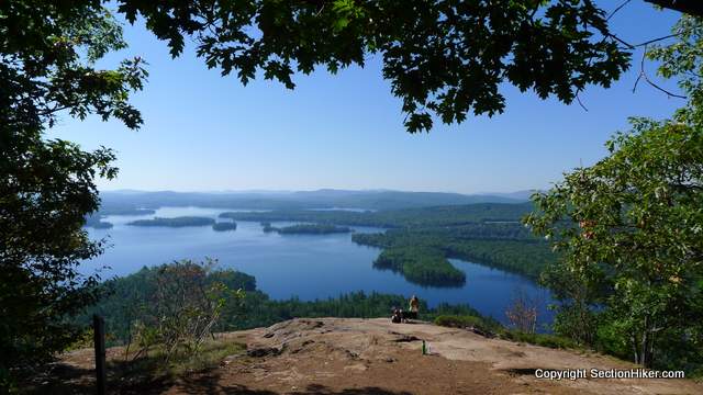
East and West Rattlesnake are two scenic peaks that overlook Squam Lake in New Hampshire’s Lake District on the southern border of the White Mountain National Forest. Moderate in height, they provide excellent views of the lake and surrounding mountains with relatively little climbing effort compared to the higher peaks up north. They’re also surrounded by a collection of lovely trails, making this an excellent destination for hiking with kids or when you still want some exercise without busting a gut. Water is somewhat scarce unless you hike down to the lake and filter some, so fill up your hydration reservoir and water bottles beforehand.

While the views from the two peaks are breathtaking, the trails that run around them are quite enjoyable hikes, providing access to several different micro-ecosystems in the surrounding area.
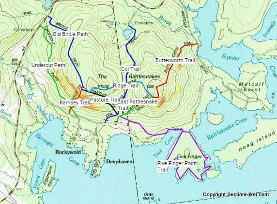
- The Five Finger Point Trail at the base of East Rattlesnakes provides access to the lake below. The trail runs along the water’s edge with access to sand beaches and swimming,
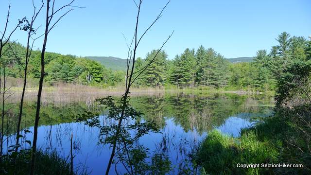
- The Col Trail provides access to a large beaver pond surrounded by high water grasses and passes close to the damn.
- The Butterworth Trail is a challenging climb from Metcalf Road to East Rattlesnake Mountain through dense woods with good rock scrambles.
There are approximately 10 miles of paths surrounding East and West Rattlesnake, which makes for a very long day if you set out to hike them all, since you’ll need to hike the same trails twice unless you use multiple cars or move yours to different trail heads. Being so close to the lake, these are also very popular trails on weekends, so I’d advise hiking on a weekday or during the off-season if you crave solitude. But the views, diversity of terrain, and natural features, make hiking the Rattlesnakes an exceptional destination, well worth multiple visits if you’re close to the Lakes region.
Recommended Maps and Trail Guides
While the paths surrounding East and West Rattlesnake are referenced in the Appalachian Mountain Club’s White Mountain Guide, they’re not depicted in the AMC’s White Mountain Map set (Grrr). The best place to get a map is from the NH Natural Heritage Bureau, which maintains the trail system.
I’ve hiked with rattlesnakes in Texas, even caught a few…
Luckily there are no poisonous snakes in the Whites, which is why I don’t mind hiking off trail here. Texas – forget that.
Hmm, there is also a Rattlesnake Ledge near Seattle that has a nice view of a lake.
The east coast had a surplus of signs, so they sold them to the west coast.
Well you forgot to include a “danger” sign, because people fall off and die once in awhile. Please send one before it starts snowing this winter.
Our danger signs get buried by the snow with some regularity. Can you send us extra tall ones first?
You can also do a loop of Mt Morgan and Mt Percival from the same trailhead. It’s about 5 miles, if I recall, and much less crowded while still offering great views of Squam (and of Rattlesnake too, since their elevation is higher).
Just hiked west rattlesnake yesterday. Easy hike and great scenery and foliage.