 SectionHiker.com Backpacking Gear Reviews and FAQs
 I just got back from what many say is the hardest section of the Long Trail: up and over Bolton Mountain (3,690 ft.), Mount Mansfield (4,393 ft.), Spruce Peak (3,320 ft.), Madonna Peak (3,668 ft.), and Whiteface Mountain (3,714 ft.)
My hike this weekend was epic, but I have mixed feelings about it. I really relish the solitude of the Long Trail but I encountered too many tourists on this last section, particularly in the Mount Mansfield and Smuggler's Notch region, that disrupted my meditations. A part of me is also glad that this section is now past me. I had a lot of trepidation before taking this hike, due to the high risk of hiking here in thunderstorms or in the rain. Happily, Vermont's weather cooperated and we had hot sunny days all weekend. The heat introduced its own set of issues, but water was still plentiful and staying hydrated was easy to manage with a little discipline.

Day-to-day mileages looked like this
Day 1: Jonesville to Taylor Lodge: 14.9 miles
Day 2: Taylor Lodge to Sterling Pond: 11.9 miles
Day 3: Sterling Pond to Johnston: 12.0 miles
Day 1:
I started my hike at 7:45 am on Friday morning at the Jonesville, Post Office on Rt. 2, at the foot of Camel's Hump, the previous northernmost point of my LT hike. From there, I walked up Stage Road to the trail head and made my way through mud and waist high shrubs, under some power lines, to a gently rolling forest path. I made it to Duck Pond Shelter in an hour, but could still hear traffic noise from Interstate 89 and was glad I hadn't spent the previous night there.
Hiking on, I startled a flock of rock hens that must have been nesting close by the trail. Most of them flew off in panic except one which actually charged me, hissing as it ran towards me! I raised my holes in a defensive posture ready to fight off an attack, but the bird streaked across the trail about 3 yards in front of me. I read about this same kind of territorial display in the trail register at the Minerva Hinckley shelter a few months ago, but it amazing and a bit amusing to experience it first hand.
After crossing a series of roads, all well blazed, I came to the spur to Buchanan Shelter and had a bite to eat. I'd covered 7.3 miles in 4 hours, and told myself to relax and take a break. The hiking had been easy up to this point but that was about to change with my ascent of Bolton Mountain.
Bolton Mountain is overshadowed by its more famous neighbors Camel's Hump and Mount Mansfield, but in certain respects it is just as hard a climb when you consider that it's a 3,500 ft ascent from Jonesville, the lowest elevation on The Long Trail. But what makes Bolton so difficult are the false summits: just when you think you've reached the top and start to descend, you start climbing again. This happens over and over again, enough to discourage even the toughest suffer-freak.

After the Bolton summit, I descended to the Puffer Shelter at 3,200 ft. Originally, built in 1954 and refurbished in 1975, Puffer is a basic lean-to, but with a fantastic view of Mount Mansfield in the distance (above). When I reached Puffer it was still pretty early in the afternoon, so I decided to try and make it to Taylor Lodge, about 3.4 miles north before sunset. This turned out to be harder than expected and it took me just under 4 hours to hike over Mount Mayo (3,159 ft) and skirt Mount Clark (2,979) descending steeply over wet ledge and down wooden ladders. When I finally arrived at Taylor Lodge, I was so exhausted that I literally staggered onto the shelter porch and it took me about 10 minutes before I could coherently converse with the other hikers staying there for the night. It had been a long, hot day, and I had consumed 10 liters of water to stay hydrated.

Taylor Lodge is a large shelter with a fenced-in porch and separate sleeping area. It's located about 1,200 feet above Lake Mansfield (above.) The water supply is a stream fed by a giant beaver pond about 0.2 miles to the north. I spent the night there with one Long Trail thru-hiker who had been on the trail for 15 days, another section hiker starting his second half of Long Trail, and a couple that planned to do Mansfield the next day.
The Long Trail thru-hiker had one item in his food bag: a really big freezer bag full of Cherios and M&M's that he was eating dry with a Lexan spoon. He said it was really easy to resupply but that he was hungry all the time. I managed to stay awake long enough to bolt down some organic pop tarts, a couple of slices of bread and a snickers bar and then we all crashed shortly after sunset.
Day 2:
I was on the trail by 7:35 am. My goals for the day were to summit Mount Mansfield, descend Smuggler's Notch, and then climb Elephant's Head Trail to Sterling Pond Shelter for the evening. This would require a 3,000 foot ascent up Mansfield, a 3,000 foot descent to Smuggler's Notch and a 2,000 foot ascent back up to Sterling Lake.
My first stop was Mount Mansfield, the highest peak in Vermont. It has several sub-peaks know as the Forehead (3,940 ft.), the Nose (4,062 ft.), and the Chin (4,393 ft.), purportedly named by Native Americans who thought the ridge line resembled a human face. Mansfield is a very exposed naked summit with precipitous, ladders assisted ascents and descents: not something you want to do in the rain or in a thunderstorm. I dreaded that possibility so much that I factored an extra day into my trip plan in case I needed to sit out a day in a shelter.

I made good time after leaving Taylor Lodge, and made it to Butler Lodge, a steep ascent of 1,250 ft. in just two hours. After a snack, I started the climb to the Mansfield Forehead which requires good rock scrambling skills. It quickly became clear that hiking poles were a hindrance, so I put them away and continued climbing without them. From here the ascent to the Forehead summit is about 850 ft in just under a mile.
Looking south from the Forehead, I had great view of all the peaks I've climbed since Appalachian Gap, some 50 miles south (below.) I'm always awestruck by the fact that I've covered this distance by foot. It's incredible how a lot of individual footsteps can add up to something so grand.

Unfortunately, it turns out that Mansfield is a major tourist attraction but I arrived early enough in the day to avoid most of the crowds. There are a number of shorter alternative hikes up the mountain and a gondola line is also available to get most of the way to the top. Given the tourist scene, I blew over Mansfield fairly quickly, only slowing down for a few brief chats with some the GMC caretakers I met along the way.
.jpg)
Summiting the Chin was a certainly a highlight, but descending down it's north face was far more exciting and less crowded. I was running low on water, so I stopped at Taft Lodge (3,600 ft.) and had a long lunch around 12 noon. I took my boots off, sat in a rocking chair on the porch and enjoyed the view. Taft is a large shelter with space for 14 people, but like Mansfield it is overrun by day hikers on summer weekends and my solitude was quickly broken by a family with young children that had decided to spend the night there.
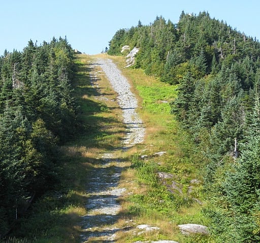
After lunch, I continued the descent to Smuggler's Notch, took in the awesome view (top photo), crossed Rt 108, and started climbing up Spruce Peak on the Elephant Head Trail. This is a far harder climb than Mansfield and reminded me of the climb up Mount Killington. The trail is blasted out of rock on the side of a mountain and snakes up and down on narrow root congested ledges. It took me about 4 hours to hike the 3.5 miles up to Sterling Pond, the site of an incredibly beautiful shelter and trail section managed by a GMC caretaker named Cody Michaels.
Cody is a big hearted guy with a huge amount of backcountry experience. We had the shelter to ourselves that night and like so many of people I've met at Long Trail Shelters, Cody understood the balance between socializing and privacy that shelter visitors require even though they're stuck in the same room together. My food was running low, because like an idiot, I left two wheels of cheese in my car, and unbidden he offered to share his dinner of curried seitan and couscous with me. I was rationing my food at this point and that carbohydrate and protein blast really helped me recover from the day's exertions. It feels good when someone passes some of that Trail Magic your way.

The sunset was stunning at Sterling Pond that evening and I got a photo (above) of the setting sun illuminating the Chin on Mansfield. It had been a long day, and I guess it's still dawning on me, as I write several days later, how far I'd traveled, on many levels.
Day 3:
It was cool when I woke at 5:15 am. A strong wind was blowing through the trees as I dozed, a sign of a cold front blowing in that threatened rain later in the day. Given my food situation, I hoped to complete the last 12 miles of my hike and get to my car by mid-afternoon or evening. The weather was also a concern because I had to hike over Whiteface Mountain, a peak that is notorious for its treacherous and often wet rock slabs. Hiking over this peak in the rain was something I wanted to avoid; I have friends who've done it and it scared the heck out of them.
I broke camp around 7:30 am and headed towards Madonna Peak, which like so many other mountains in Vermont, has been butchered by ski runs that disrupt the natural vegetation and cause destructive erosion.
However, there were some challenging pitches and very pretty scenery in between the ski runs making this a rewarding and picturesque climb.

After Madonna Peak, I hiked along the eastern slope of Morse Mountain to Whiteface Shelter, 4 miles from my starting point in the morning. This shelter, just 0.4 miles from the Whiteface summit is a primitive lean-to great view of Madonna Peak and Mount Mansfield. This is a great spot that's worth revisiting in the future and is only about 4 miles from a road, on the Beaver Meadow Brook Trail.

After a brief rest and a snack, I started the ascent up Whiteface, which was short and steep (400 ft. in four tenths of a mile). I made it to the top at about 12:00 noon and although there were some small clouds beginning to form overhead, it looked like I'd get to make the descent in dry weather. As it turns out, this descent was much easier than I feared. It wasn't easy and it was very steep (about 2,000 ft. in 2 miles), but there were only three places where I had to be extra cautious. I'm sure that the lack of rain helped matters significantly. However, climbing southbound, opposite from the way I came down, has to be murder, rain or shine.
After I made it off Whiteface, I had a fairly flat hike 4-5 mile hike down to Rt 15 in Johnston, eventually walking down a gravel road to the highway. As soon as I got to Rt 15 I has picked up by a couple that had just finished the 50 mile Long Trail section from Journey's End to Johnson, on a leisurely 8 day hike. It was funny, Windtalker and Mom pulled off the road as soon as they saw me and insisted on giving me a ride to my car which was about a half mile away at the trail head parking lot. Their car was plastered with LT and AT stickers, so I knew right away that they were cool and boy that air conditioning felt great. I really appreciated the ride, since they intercepted me as I was hiking in the wrong direction, once again following my LT map which doesn't have the location of the new trail head on it. More trail magic. But you have to give to get, so let's all start giving.
We’re planning to do the Jonesville to Johnston hike next weekend. Your description of the hike was great. My only question is how to get back to the car in Jonesville. Hitchhiking? Thanks, David Perry
That’s the challenge to walking in vermont. Find a shuttle or cab, I guess.
This really helped us plan our hike this weekend, thank you!
Call the GMC if you need a ride. There are Trail Angel Volunteers that will give you a ride. The GMC has the list.
Readers should note that the long trail has been re-routed since the article was written
I’m interested in hiking from Mt Mansfield to camels hump. Can anyone offer suggestions?
Thank you!
Denise
Your hike reminded me of a similar adventure a friend and I made the summer of ‘77, we were 15 yo so the fears did not abound! We were dropped off at the Lincoln Gap and hiked north. Having the guide books and knowing where potential water flowed inspired us. I remember names like Burnt Rock, Statk’s Nest and a cool metal ladder built into the rock wall. The white splashes of paint marking the trail are what really stand out these 44 y later! Our goal was to catch an Amtrak train home some 4 days later in Waterbury which was also part of the adventure. The Hump was fantastic and I recall swimming on a hot June day in a beautiful cold pool of water near Buchanan Lodge near the end of our journey! You may have inspired me to complete the next wonderful section of the LT!
Go for it!