 SectionHiker.com Backpacking Gear Reviews and FAQs
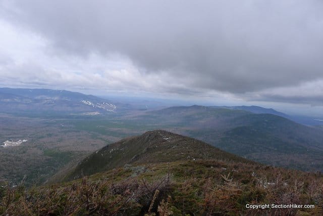
Many New England hikers consider Mount Jefferson (5712′) to be the toughest peak to climb in the White Mountains. Most of the routes to the summit require miles and miles of above-treeline exposure on a rocky ridge that is constantly blasted by a stiff north-westerly wind.
Joe C and I led an Appalachian Mountain Club hike up Jefferson on Saturday with 7 hikers. It was a tough hike, 11 miles long with 4200 feet of elevation gain. We climbed the peak via the Jewell Trail approaching from the west and continuing along the Gulfside Trail over the Monticello Lawn and up the to the summit.

Winter is still going strong in the Northern Presidentials and we were carrying full winter gear, despite the fact that it is late April. On the climb up the Jewell trail we encountered soft snow with a depth of 3-4 feet, with the beginnings of a monorail. We wore microspikes all the way up the Jewell and then along the Gulfside until Sphinx col.
This proved a little sketchy once we hit treeline and we’d knew we’d have to switch to full crampons for the steep descent. The wind picked up as soon as we broke from the shelter of the krumholz.
At the top of the Jewell Trail, the wind was blowing a sustained 50 miles per hour with gusts uo to 80 mph. The temperature was relatively warm at about 30 degrees but the wind chill was dangerous so we wore balaclavas and face masks.

Hurricane forces winds blow at 70 miles per hour, which is the wind speed where walking above-treeline becomes difficult. I was blown off my feet three times during this hike and my trekking poles were blown out of my hands more than once.
We headed north on the Gulfside Trail toward Jefferson ducking behind a natural windbreak near the final ascent to Jefferson’s summit. Here we ate and drank and switched to full crampons. After being blasted by the wind for hours, it was pleasantly peaceful and sunny.
We started the final ascent and my crampons kept slipping, getting misaligned with my boots. This was bad because we were climbing over ice-covered scree in the boulder field below the summit. I didn’t want a bad sprain or a broken ankle, with just two weeks to go before I go hiking in Scotland.
I stopped and tried to take my crampons off to readjust them but couldn’t get them to budge. I was wearing a new pair of strap-ons and they were very sharp. I must have cut myself since I started to bleed. I motioned Joe back down to help me (the wind drowned out all shouting) and after a titanic struggle, we were able to get them off. Despite some re-adjustment, they continued to slip for the rest of the hike.

We continued on up to the summit of Jefferson for a short photo-op before sitting down in the summit’s lee to eat lunch.
From there it was very slow going back to the Gulfside and the top of the Jewell Trail, our exit route. None of us had eaten or drunk enough with the constant wind in our face and people started to bonk. At our current pace, it looked like we’d be hiking out in the dark.
I reassembled the group for the descent down cautioning everyone to stay together and I got up front so I could control the pace. It took another hour before we were down into the krummholz. We changed over to snowshoes because the trail had turned soft in the midday sun and we were starting to posthole.

After more food and water, people started to recover and we had a fast-paced descent. It had been a glorious but tough day, climbing Mount Jefferson in April.
Total miles: 11, Time 11 hours: Elevation Gain 4200′
Recommended Guidebooks and Maps:
- Appalachian Mountain Club White Mountain Guide
- AMC White Mountain National Forest Map Set
- Exploring New Hampshire Map from the Wilderness Map Company
Sounds like quite a slog! I’ll be doing this in July, so hopefully conditions will have improved. : )
In July, you need to be on the look output for Thunderstorms. Seriously, all the peaks in the northern presidentials are dangerous, year round.
hell of a hike in adverse conditions! glad everyone made it through with minor injury :-)
Thanks Eric – I was literally falling asleep while typing this last night!
Phil – really a super hike. You and Joe did such a great job organizing and leading the group throughout a (very) long day. I’ve been playing it over in my mind the last couple of days and I have to rate that as one of my most enjoyable President hikes. I hope to tag along again with you on another jaunt in the future. Good luck in Scotland!
Great to have you with us Mike. You know that anybody who introduces himself at Thunderstorm Junction is probably a safe bet for one of our hikes! We did another 3750′ the next day on the Carters!
Sounds like an exciting hike, except for the crampon issues. Were you using those Hillsounds, or something else. Might be a good thing for me to know…
Really looking forward to some good posts about Scotland. I’m envious! I’m about to bust to go to Scotland, Wales, and the Lake District! Hoping I might be able to do so a couple years from now, so I might drill you for some extra information and advice in the future if you wouldn’t mind.
They were real mountaineering crampons, but I’m not willing to say which ones yet. I want to make sure I touch all the testing bases before I dis a product publicly. Not fair to the manufacturer. This was only the first time I’d used them “for real.”
No I don’t mind. I think the Scotland Board of Tourism likes me. :-)
I left a little blood in the mud on Elk Mountain last month.
I’ve rebuilt the palm of my cast three times because I keep tearing it up while working. I think the doc is going to notice my patch jobs next week…