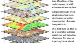
Most modern maps are generated from multiple map layers stored in Geographic Information Systems (GIS). Each map layer represents a different group of geo-referenced data points that are superimposed one on top of the another to create a composite map image. For …
Read More »Tag Archives: caltopo
Slope Angle Shading in GaiaGPS and Caltopo
One of the hallmarks of good hiking and backpacking navigation is picking trails or routes that reduce the level of effort required to climb mountains or descend into valleys. The steepness or slope angle of a trail is usually the best indicator …
Read More »Topographic Maps and Route Visualization
Some people can read a topographic map and visualize what the landscape should look like based on the shape of the contours lines shown. It’s a real skill to do it well, and while I’m pretty good at it, I can miss details …
Read More »