 SectionHiker.com Backpacking Gear Reviews and FAQs
The Passaconaway Slide Trail is an old “lost” trail that climbs an avalanche path to Mt Passaconaway, a 4000 footer in the Sandwich Range. While it’s no longer signed or listed in the White Mountain Guide, it is possible to find the old route with a little bushwhacking saavy and a climb up the steep route, which comes out at a signed viewpoint at the summit.

The 1948 AMC White Mountain Guide describes the Passaconaway Slide Trail as follows:
This trail, ascending the mountain from the N, coincides with Downes Brook Trail (see below) as far as the foot of the slide. It leaves the Albany Intervale Road on the S a short distance W of the U. of N. H. Forestry School. Crossing Downes Brook four times, the trail reaches the slide on its L, 2 m. from the road. Painted arrows now indicate the driest and easiest routes up the slide. About halfway up, the slide turns sharply R and continues more steeply to its top. Care should be taken not to start rocks rolling. From the top of the slide the trail climbs steeply through thick woods, passing a series of outlooks to the N and joins the short trail between the two outlooks on the summit. As there is no sign where the Downes Brook Trail diverges at the foot of the slide, note that this slide is the first slide to be met, and is the only rock ledge slide. This trail is dangerous, especially after a rain, and is not recommended to amateur climbers. For this reason it is not signed. Distances. U. of N. H. Forestry School to foot of slide 2 m. (1 hr. 15 min.); summit 4 m. (4 hrs.).

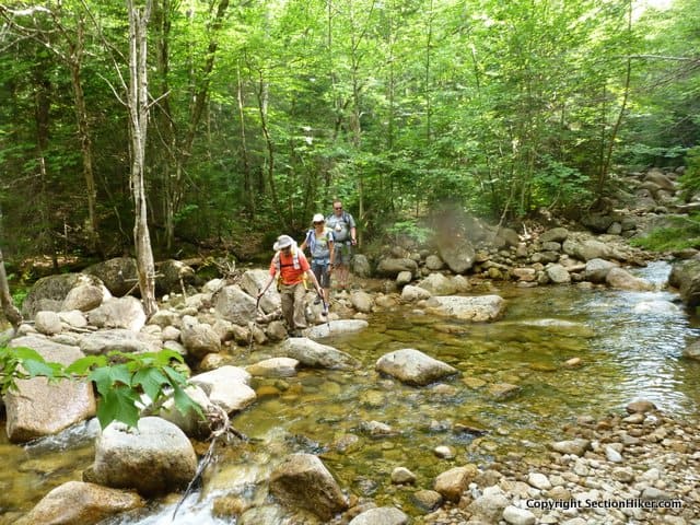
The start of the route is fairly obvious approximately two miles up the Downes Brook Trail from Rt 302, but some off-trail finesse is helpful to find a good route through the debris at the bottom of the slide. One you start up the slide proper, old blazes and cairns are visible which still mark the trail, while a mellow waterfall flows down its center.

Part way up, the slide splits into two branches at a large, shallow pool. Follow the right hand branch by hiking up the rock lined gully between the two branches. A faint trail should be evident and runs back and forth across the slide as it climbs steeply through thick woods. If you look carefully, you can see indications of old trail maintenance (pruned branches and sawn logs) that indicate the route. While climbing, I could catch glimpses of the upper slide through the trees, which looked impossibly steep and wet to climb without climbing protection.

The slide ends at a gully at about 3500′ while the old trail keeps climbing up the ridgeline crest to the summit viewpoint through increasingly open woods. We didn’t meet anyone until we reached the summit loop around Passaconaway, which was crawling with hikers on a busy summer Saturday.

From the Passaconaway summit, we followed the Rollins Trail to the cairn on top of Mt Whiteface, before following the Kate Sleeper Trail back to the Downes Brook Trail for the 5.2 mile hike back to our cars. It’d been 10 years since I last hiked the Downes Brook Trail in its entirety, which requires 11 stream crossings back and forth across the river. It seemed like yesterday because the trail hasn’t changed that much during the interval, except for top of the trail where it meets the Kate Sleeper Trail.
This area has been trashed by wind, snow, and avalanche damage with a large number of blowdowns including multiple sections of trail that have been washed away. If you’ve considered hiking through this area in winter, I’d think again. I can’t imagine being able to traverse the section on snowshoes, let alone find the trail in deep snow.
Most of the Downes Brook Trail is not blazed, which is common practice in White Mountain wilderness areas. There were a few places where we had to scout around to find the trail or it was overgrown by hobble bush and spruce. Just be patient and remember that the trail follows the river. Knowing that you can always hike downstream until you pick it up again if you lose the trail.
Climbing the Passaconaway Slide and looping back down the Downes Brook Trail is a great loop hike, but a long one, nearly 13 miles in length with close to 4000′ of elevation gain. Don’t underestimate the difficulty of climbing the slide, which would require bushwhacking through dense vegetation on a steep slope unless you can find the old trail.
Recommended Guidebooks and Maps:
- Appalachian Mountain Club White Mountain Guide, 31st ed.
- AMC White Mountain National Forest Map Set
- White Mountains Map: New Hampshire and Maine
Adam’s Slide Trail next? I really like these reports on abandoned trails. With a little research and some diligent map-work it’s still possible to find “new” adventures in the tired old White’s. Whenever I’m on a really gnarly section of trail I think about how hard it must have been to have actually cut the path through the krumholtz.
I’m humbled by the strength of our predecessors.
On my short list too! Spent the last two years redlining which was great, but now I want to do a few more freeform hikes like this one. We’ve even talked about redlining the lost trails.
Redlining lost trails is a really, really cool idea.
How about some truly lost trails?
Scout Trail in the Wild River drainage and Stillwater Bypass
Both of those might be a fool’s errand.
I made it all of 200 yards from the presumed northern terminus of the Stillwater Bypass off of the Shoal Pond Trail; that is some spooky woods in there.
Woodbury Trail from Waterville Valley to the West Spur of Whiteface was hit or miss after the turn off to Lost Pass but the western section is definitely maintained.
Those are good too:
Check out the Sinclair Trail – parallels peabody brook trail in the Mahoosucs. Runs from the peabody brook TH to West Trident. I’ve had my eye on that one for a while.
Also the Carlton Notch Trail Trail from the vanished town of Hastings in Wild River to Howe Peak and Shelburne Moriah.
“vanished town”
Ooo… intriguing!
Hi Phil,
this past winter we attempted a Whiteface summit via Downes Brook and Kate Sleeper. Trip report here: https://www.newenglandtrailconditions.com/nh/viewreport.php?entryid=46696
At the sign at the Sandwich Wilderness border we noticed the slide to the left heading up toward Passaconaway, and I did some Googling later that day and found this post. I made a mental note to attempt this some dry fall day. Well, here we are in fall and I’m planning a hike for next weekend. I wondered if you might still have the GPS track and if so, would you consider sharing it. While I am confident that we could find the old trail based on this post and the evidence of old trail maintenance, Pumba (my better half) would feel better if we had an GPS track loaded on two phones in case I croak going up and she needs to solo out (after summiting, of course :-)).
Thanks for this post and all the others on your site. I’ve probably read half of them and look forward to the other half!
Notch
I didn’t record a track. You don’t really need one. It’s pretty obvious.