June 7, 2023 Bushwhacks
Unknown Pond Peak is the 100th highest mountain on the New Hampshire Hundred Highest peakbagging list, a list that I’ve been slowly working on since 2012. I haven’t done an off-trail trail hike for a while since I’ve been pursuing The White …
Read More » April 25, 2023 4000 Footers
Mt Moriah isn’t the highest White Mountain 4000-footer, but it requires 3200′ of elevation gain to climb which makes it one of the more strenuous peaks to ascend. There are a number of different trails you can use to climb it, but …
Read More » April 20, 2023 White Mountains
Spring trail conditions in New Hampshire’s White Mountains can be quite unpredictable depending on your location and elevation. Despite the change in season and longer days, snow usually lingers on the high peaks well into May, and daytime temperatures remain quite chilly, …
Read More » April 14, 2023 4000 Footers
There’s an expression in the gridding community called “gridding out” a mountain when you finish hiking it at least once in every calendar month. You need to do that for each of the forty-eight 4000-footers on the White Mountain 4000-footer list to …
Read More » April 5, 2023 4000 Footers
Mt Isolation is one of the most remote White Mountains 4000-footers and can make for a long day in any conditions. Being April, you might think that spring has arrived in New Hampshire, but it’s nowhere close. We’re still contending with full-on …
Read More » April 3, 2023 Free 4000 Footer Guidebook, Most Shared
A Presidential Traverse is one of the most famous and strenuous hikes in the White Mountains. This 2-3 day route is 25 miles in length with a cumulative elevation gain of 9,000 feet. It climbs eight 4000-footers with 14 miles of above-treeline …
Read More » April 1, 2023 Free 4000 Footer Guidebook, Most Shared
A Pemi Loop, as it’s known locally, is a 33 mile loop hike that follows the ridgeline encircling the Pemigewasset Wilderness. This 2-3 day route climbs TEN 4000 footers with 9000 feet of elevation gain and has long stretches of above-treeline travel, …
Read More » March 30, 2023 Free 4000 Footer Guidebook, Loop Hikes
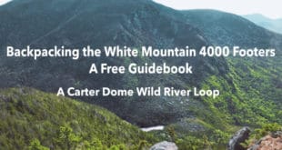
Carter Dome is the ninth tallest White Mountain 4000 footer with an elevation of 4832 feet. It’s located almost due east of Mount Washington and has the distinction of being the highest mountain in the Carter Moriah Range. Most of the peakbaggers …
Read More » March 29, 2023 Free 4000 Footer Guidebook, Loop Hikes
Oakes Gulf is a glacial cirque on the south side of Mt Washington, similar in size and scale to Tuckerman Ravine, but much harder to access because it’s so far from a paved road. Home to the avalanche-scarred Dry River, which isn’t …
Read More » March 28, 2023 Free 4000 Footer Guidebook
A Willey Range Loop is a moderate 2-3 day, 22 mile loop that climbs four 4000-footers: Mts Tom, Field, and Willey in the Willey Range, before looping past the magnificent Thoreau Falls, Zealand Falls and climbing Mt Hale on the opposite side …
Read More » March 27, 2023 Free 4000 Footer Guidebook, Loop Hikes
The Fire Warden’s Loop is a 2-3 day, 18 mile backpacking route that climbs four 4000 footers: Hale, Zealand, South Twin, and North Twin. All four of these peaks surround the Little River Valley but aren’t normally climbed together as a group …
Read More » March 25, 2023 Free 4000 Footer Guidebook
The White Mountain landscape is defined by its mountain passes (called Notches), perhaps even more than its peaks. Crawford Notch, Pinkham Notch, and Franconia Notch are just a few of the great valleys that channel visitors from one region of the White …
Read More » March 23, 2023 Free 4000 Footer Guidebook
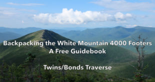
A Twins/Bonds Traverse is a 2-3 day, 20-mile traverse of North Twin, South Twin, West Bond, Mt Bond, and Bondcliff Mountains. This route is an alternative to the classic Bonds Traverse which approaches the Bondcliff Trail from the east over Mt Zealand. …
Read More » March 22, 2023 Free 4000 Footer Guidebook
This trip has it all: great views, an epic ridge walk, a fire tower, two alpine lakes, moose habitat, waterfalls, and cascades. Mt Carrigain is at the geographic center of the White Mountains and on a clear day you can see over 30 …
Read More » SectionHiker.com Backpacking Gear Reviews and FAQs