 SectionHiker.com Backpacking Gear Reviews and FAQs
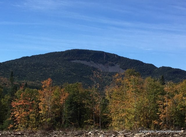
Climbing Mount Magalloway is a serious pilgrimage. A five-hour drive from Boston, Magalloway is located deep in the heart of New Hampshire’s North Country, just a few miles from the US-Canadian Border. It’s a wild place, where 4 x 4 trucks outnumber passenger cars, 10 to 1 and most of the roads are unpaved private haul roads built and maintained by lumber companies. This was my first solo adventure to northern New Hampshire and I was a little nervous about navigating the roads with my beat-up low clearance car.
White Mountain Guide in hand, (the 29th edition) the directions to Magalloway and all of the other north country destinations I visited up were excellent. Mind you, they’re old school directions, like “drive down the mail haul road for 5.3 miles and take the second gravel road to your right,” not new-fangled GPS lat lons. I doubt the White Mountain Guide will ever modernize that way and that’s just fine with me.

Magalloway (3383′) is the most northernmost peak on the 52-with-a-View peakbagging list which I’ve been slowly chipping away since 2006. It’s a collection of great hikes, many with jaw dropping views, and well worth hiking. The peaks on it are easier than the White Mountain 4000 footers, but much more scenic. It’s a good list to work after you finish the 4000 footers or as preparation for hiking the higher peaks.

Magalloway is also notable because it has a publicly accessible fire tower on its summit as well as a primitive cabin that you can rent, until the end of Columbus Day. When I climbed the peak, I met the caretaker, who told me all about the cabin’s amenities, which include free firewood, a propane stove, a screened in porch, and enough beds to house a small family. There’s no running water, although there is a spring nearby (which was dry when I visited.) The cabin is less than a mile from the trailhead, so worst comes to worse, you can carry your own water up.
While you can climb the fire tower, you can’t go inside the cabin at the top. It is still manned periodically, but it’s very difficult to become an observer unless you work for New Hampshire Forest and Lands. I asked.

There are four trails on Magalloway: the Bobcat Trail (0.8 miles), the Coot Trail (0.8 miles), the Magalloway Spring Spur (0.1), and the Magalloway Overlook Path (0.2 miles) which overlooks the avalanche slide that scars the north face of the mountain. The Coot and Bobcat Trails form a loop from the parking lot and are fairly steep, but short. None of these trails were that interesting to hike, but the views overlooking the avalanche slide and from the fire tower were worth the climb.

I climbed Magalloway on the last week of September, when the leaves were changing, but about one week before peak color. Still it was a pretty sight, to see a sea of orange and red sweeping across the forest below me.
If you make the journey to Magalloway, I recommend you visit the Garfield Falls Trail and the Falls in the River Trail, which are both nearby. They’re both lovely, quite well-marked and well maintained, and provide access to some excellent fly fishing if that’s also of interest. While the hiking trails in New Hampshire’s North Country can’t compete with those down south in the White Mountain National Forest, they have their own unique allure. While the North Country is wild, it’s wild in a friendly way, and still easily accessible for those who want some off the grid adventure.
I was up there this past July and it really seems like you are entering a different country. I was coming from mid-state Vermont so had to take a number of different roads to reach nearby Pittsburg. At one point I recall seeing a sign that read “Moose crossing next 15 miles”. I would add that if you plan to hike the Coot Trail, the second gravel road was 3.1 miles and a bit rougher than the first with exposed culverts in places. I shadowed a moose for a short ways lumbering along the edge of the road. It was great to find a fairly clean privy at the trail head. The Coot trail is steep and rocky. The views are great from the fire tower. The 52WAV is a great list with lots of variety.
I feel like I’m an explorer when I go up there, which I find very invigorating. I plan to spend a lot more time up there next year.
Hallo Werner,
so did you spend a lot more time in the Nash Stream Forest?
I am planning a trip to Magalloway this year.
Marianne Page
I’m pretty sure Megalloway is not in the Nash Stream Forest.
But yes, I am hiking the Nh500 and there are several dozen Trailless peaks in the Nash Stream Foret that I plan to climb as soon as the road opens which should be in about 6 weeks.
I visited this mountain last spring. Really not much going on up there, although as you say it is wild country. I met a few people in the closest town (forget the name of it) and they stared at me like I was an alien. Very unfriendly. I expected better of simple, living-off-the-land type people. Will not be returning to that area, though it was beautiful.
They lighten up when you wear blaze orange.
Well that is true I’m sure, Phil. But I was still surprised. I felt very uncomfortable walking into the general store with a bunch of toothless hillbillies staring back at me.
Wow! Toothless hillbillies. Maybe you should stay in your Range Rover next time and use the drive through. Those people live up north for a reason that you probably can’t understand.
That view north into Canada is interesting. Is that 20 yard wide cleared area along the border common ?
yes, but this is about 7 miles from the border. I did the hike the border swath a short while later the same day up to 4th Connecticut lake which is considered the source of the Connecticut River.
Was just in Pittsburg by Magalloway and never once felt uncomfortable or saw anyone toothless. As a matter of fact the guys working in The Treasures Convience store , were friendly, helpful and pretty damn intelligent. Maybe loose the stereotypes pre planted in your mind. Lisa from Mass
Every few years I take a fishing trip up there and have climbed Magalloway. I stayed at ths tate park and when asked what I did, I said I threw a stone across the Conneticut River! Also – check out the history of the Indian Stream Republic!
Good article. The country north of Berlin has always fascinated me. Now you provided a reason to get up there. That and the really dark skies.