 SectionHiker.com Backpacking Gear Reviews and FAQs
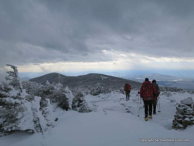
Mount Moosilauke is the westernmost 4000 footer in New Hampshire with a bald summit that is greatly exposed to the weather and the wind. My friend Bob and I led a winter hike up to Moosilauke and its southern sub-peak recently, climbing the mountain via the Carriage Road Trail from its base on Breezy Point Road. This trailhead was once much more popular than it is today, although it’s still used by backcountry skiers who can ski the 4.3 miles down the trail, dropping over 3000 feet from the summit ridge.
Leaving the small parking lot at the base of the trail, the Carriage Road Trail climbs up the south-eastern side of the mountain, winding through open forest. Maintained by the Dartmouth Outdoor Club, the trail was originally used to transport guests to Prospect House, a hotel built on Moosilauke’s summit, but now long gone.
The bottom of the trail runs through the watershed and headwaters of the mighty Baker River before gradually climbing Moosilauke with switchbacks, passing the Hurricane Trail on the left and the Snapper Ski Trail on the right. The Snapper links the top of the Carriage Road to Ravine Lodge, a rustic hut owned and operated by the Dartmouth Outdoor Club.

Past the Snapper, the trail steepens and starts to climb, but still remains protected from the weather by tall spruce trees that line the path on either side. The wind protection was welcome on the day of our hike because the Higher Summits Forecast had called for 80-90 mile per hour winds. Based on experience, I know that forecast is usually localized to the Northern Presidentials in Pinkham Notch on the eastern edge of the White Mountains and less relevant for Moosilauke which is on the westernmost edge. Still a low pressure front was blowing through the Whites that day so extra caution was warranted. (See my article on Weather Forecasting in the White Mountains for tips on how to interpret different information sources when planning winter hikes.)
Given the wind forecast, I built a few checkpoints into our trip plan where we could assess the wind speed and its severity before committing to the main summit. Moosilauke has a subsidiary peak that I like to climb called South Peak, which is off the Carriage Road Trail on the way to the main ascent. It’s about 300 feet lower than the main summit and close to the trees, making it a good destination to assess the wind’s force.

When we reached the top of the Carriage Road Trail where it intersects the Glencliff Trail, we hiked down the short spur trail to the South Peak. The wind turned out to be brisk but probably closer to the 25-35 mph level predicted by the NOAA spot forecast I’d read earlier that morning. We hiked back to the Carriage Road Trail and made our way towards the main summit, another 0.8 miles further along the summit ridge.
There’s a point on the Carriage Road Trail, about 0.2 miles below the summit where the protection of the krumholz trees ends and the approach trail to the main summit is fully exposed to wind and weather. The trail here is marked by giant cairns and the ground is often covered by thick ice.
I asked everyone on the hike switch over from microspikes to full crampons and put on full face protection and goggles for the final leg to the summit. I felt that the added face protection was a worthwhile precaution. It certainly made for a far more comfortable and warm hike in the cold wind.
We hiked slowly towards the summit sign in single file with Bob leading the group and me sweeping. The ice was thick and hard underfoot and I was glad for the extra traction. We tagged the summit sign and headed back down to the protection of the trees. The views opened up on our descent and we could see nearby Mt Clough and Mt Jeffers and Vermont’s Green Mountains in the distance. Moosilauke is a grand peak when you get blessed with an open sky.

It was 2:30 when we got back to the trees and shed our above treeline gear. From there, I led a fairly blistering pace back down the mountain, covering the 5.1 mile descent in just 2 hours. Gravity was our friend. This was an exceptional hike and I can really recommend the Carriage Road Trail as a good winter route for climbing Mt. Moosilauke.
Total Distance: 10.3 miles with 3100 feet of elevation gain.
Recommended Guidebooks and Maps:
- Appalachian Mountain Club White Mountain Guide, 31st ed.
- AMC White Mountain National Forest Map Set
- White Mountains Map: New Hampshire and Maine
Updated 2017.
SectionHiker is reader-supported. We only make money if you purchase a product through our affiliate links. Help us continue to test and write unsponsored and independent gear reviews, beginner FAQs, and free hiking guides.
Philip, I really enjoy reading your trip reports. I haven’t climbed Moosilauke this way, but I’m going to check it out this spring.
It is great fun hiking all the different routes to the Moosilauke summit. I think it may well be my favorite mountain in the Whites. It was the first 4000 footer I ever climbed.
It was my first 4000 footer too – and we took this trail one day while staying at the Dartmouth Ravine Lodge – it was a wonderful trip!