 SectionHiker.com Backpacking Gear Reviews and FAQs
I never expected to revisit Speck Pond after hiking the section of the Appalachian Trail from Grafton Notch down to Gentian Pond in 2009. Speck Pond is on the south side of Old Speck Mountain, a huge 4000 footer with a fire tower at the top. There’s a lean-to shelter and tent platforms there, and I remember camping under a tarp during a violent thunderstorm, helplessly watching the water pool on the tent platform boards and head in the direction of my sleep insulation. The next morning, I’d hiked through famous Mahoosuc Notch headed southbound on the AT. That was 8 years ago.
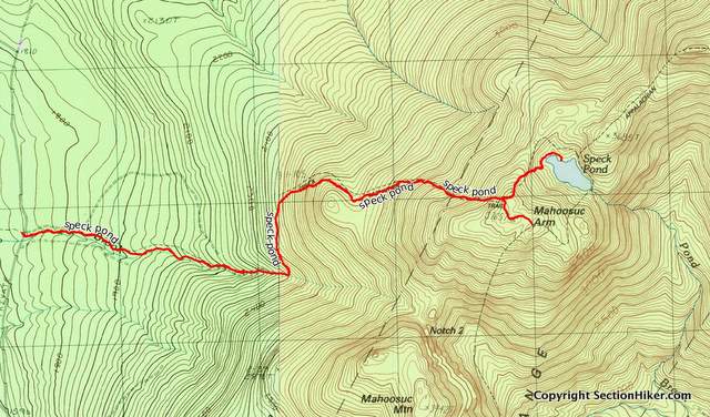
Only this time I hiked in on a blue blazed trail called the Old Speck Pond Trail, one of several that connect the AT to Success Pond Rd, a gravel topped logging road which is one of the main backcountry thoroughfares in this part of the north country. My destination was a peak called Mahoosuc Arm Mountain, which overlooks Speck Pond and Mahoosuc Notch, followed by the pond below it.
Success Pond Rd is a hoot, but not if you have a low clearance car like my Mazda 3, since there are places where its severely eroded. It’s a privately owned logging road where logging trucks have right of way and is an important short-cut between Berlin, NH and Grafton Notch, ME, cutting off an hour of highway driving time. Cell phone access is non-existent, so you have to have a vehicle you can trust when driving it, since sections of it are quite isolated.
Most of the summer traffic on Success Pond Road is locals in 4×4’s, ATV’s, and some AT shuttle drivers ferrying thru-hikers and section-hikers to and from the Mahoosuc Trail segment of the AT. The road is closed in winter, although parts of it are used as a snowmobile trail. I only started using it myself a few years ago to get to remote trails and bushwhacks in the Mahoosuc Range, but like I said, it’s best travelled with a high clearance vehicle you can rely on.

The Old Speck Pond Trail, like all of the hiking trails in the Mahoosuc Range, is rough and steep, wet, and full of rocks. They’re even tougher than the trails in the White Mountain National Forest, down south. This one looked fairly well maintained however, probably because the shelter at the pond is being replaced this spring and the work crews hike up to the pond and back from the road, about 3.5 miles one way.
This being spring, the leaves hadn’t come out yet and didn’t block the view from the trail, so I could see much of the north country spread out before me including the Percy Peaks and the Devil’s Slide near Stark, New Hampshire. Higher up on Mahoosuc Arm, I could see Goose Eye Mountain and the Wright Trail Cliffs, two other peaks I climbed last summer about 10 miles south on the Mahoosuc Trail (AT).
That Goose Eye Trip was a doozy. I’m always kind of awed when I see big mountains that I’ve climbed, just knowing that I managed to hike up them on my own. There’s a certain satisfaction, even an affirmation that “I exist”, that comes from knowing I stood on top of those peaks.
The Old Speck Trail doesn’t come out at the pond, but high up on Mahoosuc Arm Mountain, and I had to give up a lot of elevation to get down to the water and the AT campsite there. It’s a really steep and wet trail, and this one still had snow in it, it being early June. Nothing like spring in New England!

I toured the new shelter area – the old one was a dump when I’d visited the last time – and then headed to the pond for a snack. There I met a fisherman, actually a hiker with a fishing rod, who was rigging up a spinning rig to fish. He lives in Bethel, Maine and we talked about hiking and fishing in the area. Just a nice low key chat. Then I took my leave and hiked back up the trail and back down to my car below. It was eery lonely hiking back down through the hobble bush, so I sang a few songs to scare away any bears and moose in the area.
Speck Pond does look like it has a nice fish population and I bet you could have some fun paddling around in it in a packraft. But I don’t know when I’ll be back there again.
Total Distance: 7.8 miles, 2500 feet of elevation gain.
Written 2017.
Got me thinking of driving down success pond rd just to do the Notch. May do that.