 SectionHiker.com Backpacking Gear Reviews and FAQs
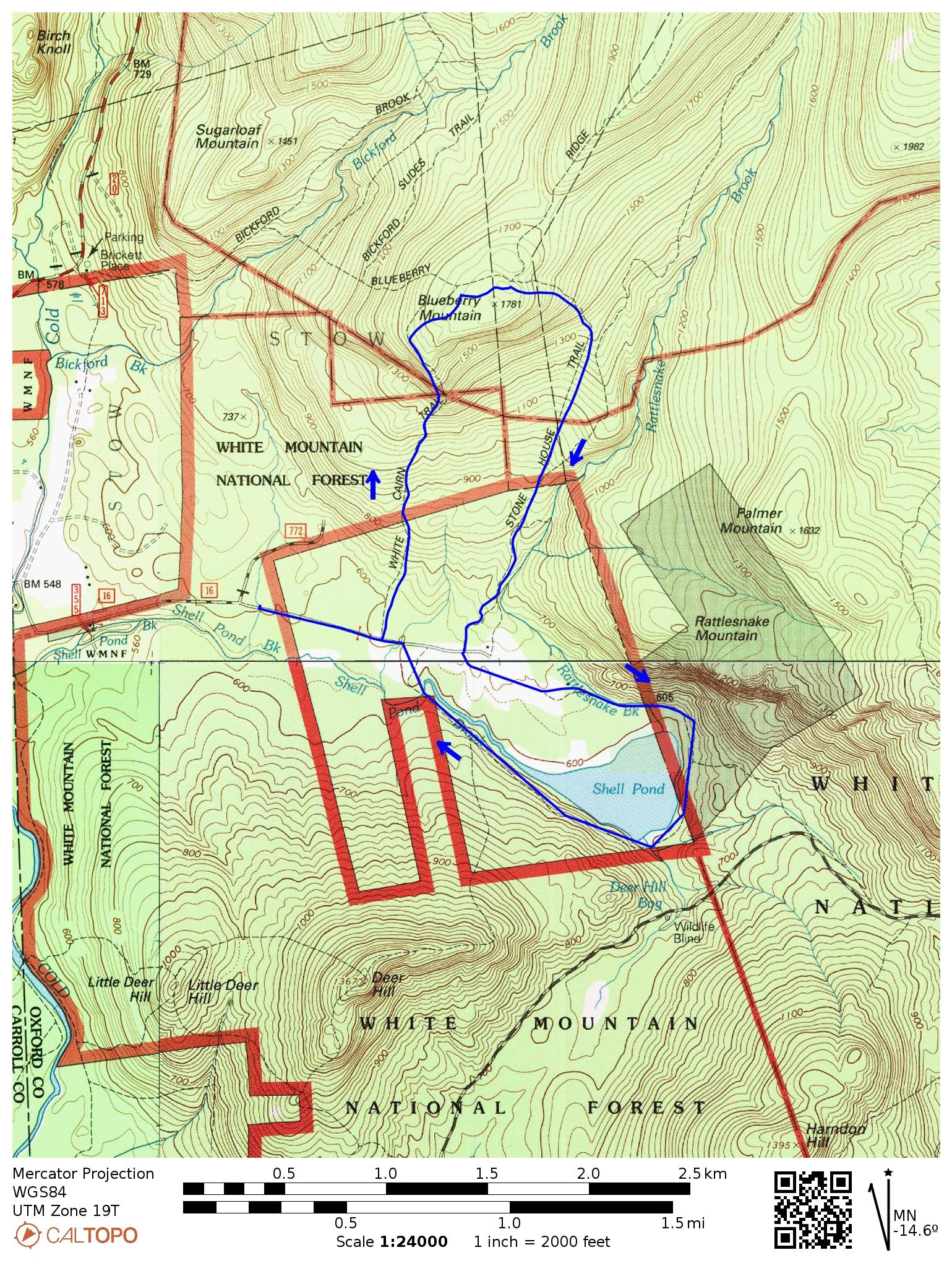
Blueberry Mountain is a small mountain in Evans Notch that has an easily accessible alpine zone and great views without a lot of climbing. It’s located near Brickett Place off Rt 113 and overlooks a private estate, pond, and well-maintained trail system that the owners have made accessible to hikers. There are actually two loops that you can hike here, one that climbs Blueberry Mountains and crosses into the Caribou-Speckled Wilderness, and one that loops around Shell Pond and the estate grounds. If you’re feeling energetic you can hike them as one continuous loop or as separate loops. Both of them also make great family hikes with kids.
- Difficulty: Moderate
- Length: 2.8 miles (1150′) and 2.8 miles (mostly level)
- Scenic Highlights
- Lookout Trail
- Rattlesnake Pool (Swimming hole)
- Rattlesnake Gorge
- Shell Pond Airstrip
- Shell Pond
- Water: Mountain streams and ponds
- Trails:
- Blueberry Loop:
- White Cairn Trail: 1.1 miles (1150′)
- Lookout Loop: 0.4
- Stone House Trail: 1.3 miles:
- Shell Pond Loop
- Shell Pond: 0.9 miles
- Shell Pond Loop: 1.9 miles
- Blueberry Loop:
Directions
The parking area for both loops is on Stone House Rd which is 0.7 miles north of the AMC’s Cold River Camp off Rt 113. Drive 1.1 miles east, bearing right until you come to a closed gate and park here.
White Cairn Trail
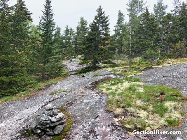
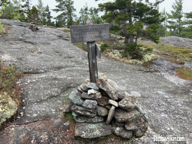
Pass through the gate and walk 0.2 miles to the White Cairn Trail sign, turning left to enter the forest. The trail follows an old logging road before climbing up stone stairs with moderate scrambling over open ledge. Pass the Caribou-Speckled Wilderness Area sign and hike over rock ledge with views of the Baldfaces and Royces to your south and west. This trail has the most elevation gain. It ends when you reach the signed Blueberry Ridge Trail Junction and a large rock cairn.
Lookout Loop
Follow the sign to the Stone House Trail, turning right at the sign for the Lookout Loop. This loop runs around the south side of Blueberry Mountain with views to the Deers and Shell Pond below. It’s a pretty place to sit. Follow the trail to its end, where it rejoins the Stone House Trail. The signage here can be a little confusing but there are rock cairns that lead to the Stone House Trail and back down toward the estate.

Stone House Trail
Follow the trail as it passes through forest and drops down below treeline into the forest, before following an old logging trail. Near the end, look for a sign to the Rattlesnake Pool swimming hole. Don’t worry. There are no rattlesnakes in this part of New Hampshire. The name is probably a reference to the winding brook that feeds the pond.
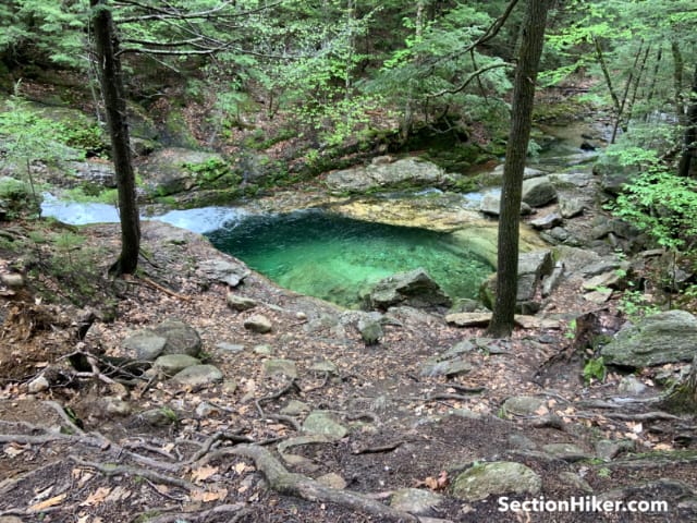
Follow the sign a short distance to the pool, retracing your steps to exit. Make a left onto the Stone House Trail. There’s another short side trail on the left leading to a bridge over Rattlesnake Gorge, the outflow of the pool. Continue on the Stone House Trail until you reach the estate road. Make a right to return to the parking area or a left to continue to the Shell Pond Loop.

Shell Pond Trail
There will be a large field directly in front of you. Turn left (east) and follow the dirt track down the center of the field. This is an airstrip, although the estate residents also use a helicopter. Pass a large cottage surrounded by a short stone wall. The house has a sign on the outside that reads “The Stow Airport.” Continue past the house following the beaten track through a forested field before reaching Shell Pond on your right. The Shell Pond Trail continues in front of you.

When you come to a trail junction marked Shell Pond Tr/Shell Pond Loop Tr, bear right and continue on the Shell Pond Loop Trail which loops around the pond clockwise. See if you can spot the beaver lodge in the pond. The leads to a stone bench which has a view of the pond and is a good place for a break. Continue on the trail which loops around the pond before bringing you back to the entrance road near the parking area.
Recommended Guidebooks and Maps:
- Appalachian Mountain Club White Mountain Guide, 31st ed.
- AMC White Mountain National Forest Map Set
- White Mountains Map: New Hampshire and Maine
Enjoyed your article but The Estate Residents do not own or use a helicopter and/or plane.
The airstrip appears on old aviation maps as a place for emergency landings.
Small airplanes do land on the airstrip once in a while just for fun.