 SectionHiker.com Backpacking Gear Reviews and FAQs
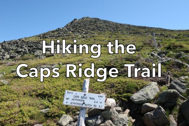
The Caps Ridge Trail is a popular above-treeline trail in the White Mountains because it’s the shortest route to climb Mt Jefferson (5712′), the third-highest 4000 footer on the AMC’s 4000 footer list. The trail starts in the forest and gradually climbs above treeline over a series of rocky outcrops called Caps, before climbing a boulder field to the summit. The Caps Ridge Trail is also a good way to get to the Sphinx and Six Husbands Trail, the Clay Loop, Mt Adams, and the Randolph Mountains Club’s shelters and tent site on Mt Adams.

Hike Description
- Difficulty: Strenuous. Involves rock scrambling and walking across boulder fields.
- Distance: 2.6 miles (2.5 miles to the summit of Mt Jefferson)
- Elevation Gain; 2700 feet
- Water: Bring at 2-3 liters per person. The rocks on Mt Jefferson absorb and radiate a lot of heat and you’ll probably want extra water.
- Caps Ridge Trailhead Directions: (GPS: 44.29657, -71.35388) The Caps Ridge Trailhead is on Jefferson Notch Road, a seasonal and gated gravel road. The easiest access is via the south side, directly across from the Mt Clinton Rd (also seasonal) on Base Station Rd, which is the paved road (watch for big suspension crunching bumps) that links Rt 302 to the Cog Railway station. The high point is 3.4 miles up. Keep your speed down because the road is narrow and people will be driving down. Parking is available for about two dozen cars.
- Blazing: Yellow blazes below treeline and rock cairns above treeline. The blazing, if painted on rocks, can be very hard to see because it flakes off over time. Above treeline, hike from cairn to cairn rather than wandering over the rockpile to avoid damaging rare alpine plants that live on and in between the rocks.
- Recommended Maps and Guidebooks:
- Season: July-November. Jefferson Notch Road is closed during winter and usually only reopens the last week of June.
- Dogs: Permitted, but you make need to carry your dog between large gaps in the rocks.
- Camping: Camping is forbidden above treeline throughout the White Mountain National Forest. The nearest campsite is the RMC Perch Shelter and Tent Platforms located on the north side of Mt Adams, but these are closed thru 2020 due to the Pandemic. Please observe all White Mountain National Forest Backcountry Camping Regulations.
On the Trail

While many people hike the Caps Ridge Trail to reach Mt Jefferson, it also provides good access to several other trails and destinations in the Northern Presidential Range. Don’t underestimate this trail despite the fact that it climbs to the Jefferson summit over a short distance. It still averages over 1000 feet of elevation gain per mile, which makes it one of the steeper climbs in the White Mountains.

The trail starts fairly gently, running through the forest and up well-maintained stone steps for the first 1.1 miles up The Link trail junction. From there the trail narrows and the trees get progressively shorter in height until you break out above treeline at close to 4000 feet. Look for a short spur trail to your right which has a great view of the ravines below Mt Washington and the Southern Presidential Range. This is where the Caps begin.

The Caps are rocky outcrops that require some scrambling to get over. They’re marked with a combination of yellow blazes and rock cairns. The yellow blazes may be quite faded, however, since the paint flakes off with age. The route is pretty easy to make out however, as long as you think “up.”
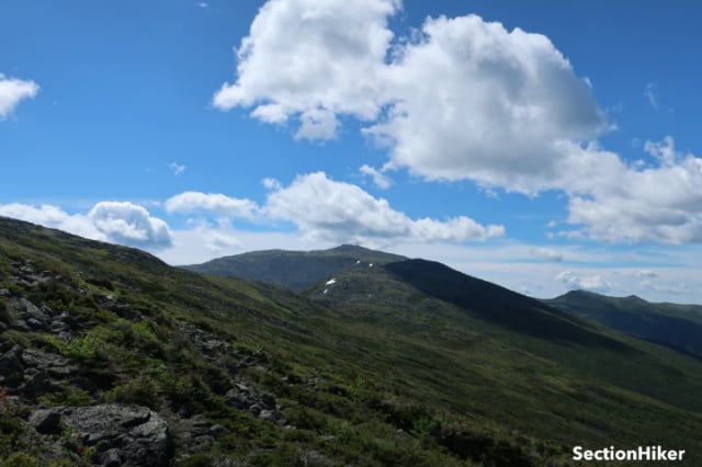
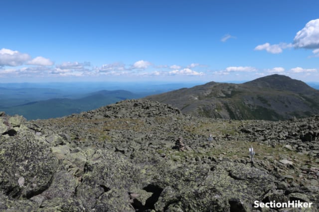
At 2.1 miles, you arrive at The Cornice Trail junction. From here on to the summit of Jefferson, the Caps Ridge Trail follows a series of cairns as it climbs through a boulder field. It’s important to stay near the cairns to avoid disturbing alpine plants which have a very short growing season above treeline (since snow covers them most of the year). The footing on this section of the trail is tricky, so go slow. In summer, the boulders retain a lot of heat, so I suggest bringing extra water on this hike.

The top of Mt Jefferson is one of the windiest places in the White Mountains and as you approach the summit you will probably feel a strong breeze and a chill on a cool day. It’s very easy to walk right past the Jefferson summit because it just looks like a big pile of rocks. If you find yourself at a huge rock cairn on top of the mountain, you’ve walked past the summit. Turn around and hike back a few steps and climb the mound of rocks to your right with a squat rock cairn at the top. There are numerous signs on top of Mt Jefferson that mark the trails leading off the peak, should you desire to continue to other destinations from the summit, or reverse your route and hike back down the Caps Ridge Trail.
Would that be a good place to start for a half traverse of the Presis?
I’m not sure what a half traverse includes. It is a relatively easy way to get up to the ridge though.
For me the half-traverse was going up Caps then over to Washington/Monroe/Ike and down Edmands. That’s how I completed my 48. Not sure my legs could do a full traverse but this was a good secondary option!
Yes. You can take the Valley Way down.
No idea what you’re talking about. Most people start a traverse on Valley Way.
Saw my comments made in 2020. I mean one can do the Northern Presidential Traverse starting from Caps Ridge Trailhead, hiking over Mt Jefferson, Adams and Madison, and taking the Valley Way down.
Great article as always. I wish I had known you were doing coverage on caps ridge trail because I have many photos shot with the Sony A7iii
I just did part of the traverse the last two days starting with Madison and ending with Pierce. We stayed in the Lake of the Clouds hut one night. . Was traveling with someone with a not too strong ankle, so slow going and we decided not to summit Jefferson so we wouldn’t miss dinner and chance getting there in the dark. Is the Caps Ridge Trail the best way for me to do on my own in the next few weeks? Just on one day hike so I can add that to my 4000 footers. I’ve done Adams, and Washington a few times but this would be my first hike up a 4000 by myself. Thanks for any advice
Probably. It’s certainly the shortest since the trailhead is at 3000. But is it the best? Not by a long shot. But you have plenty of time to discover the other routes. Just check the weather before you go. The rocks (it’s extremely rocky) would be very slippery if wet and July is the height of thunderstorm season.
Thanks! I’ll check out the other trails.
Is there any places to camp by the trailhead? Just looking to setup a spot near that trail area to crank out a few day hikes over a long weekend. Just curious.
there are free designated campsites all up and down the sides of Jefferson Notch Road that you can car camp from.