 SectionHiker.com Backpacking Gear Reviews and FAQs
Mt Carrigain (4700′) is a beautiful mountain on the southeast edge of the Pemigewasset Wilderness that boasts a viewing tower and a magnificent open ridge walk below the summit. It’s normally a 10 mile out and back hike with a whopping 3400′ of elevation gain in three-season weather. But once the forest service road to the trailhead closes in winter (usually by the end of November), it becomes considerably more challenging because you have to walk the now-gated road an additional 2 miles in and back, with another 500′ of elevation gain. That makes it a much longer day.
The last time I climbed Carrigain in “winter conditions” was in February of 2015, but I had a pretty good idea of what to expect on this hike based on recent trips reports posted on New England Trail Conditions. Still, I knew this would be a long hike and that we’d probably come back out in the dark. We did.

There’s been a big melt-off of the snowpack in the past week in the Whites, followed by a refreeze. This has created very icy trail conditions that require much sturdier and longer crampons to penetrate the sections of heavy ice, rather than just microspikes.
On this trip, I carried microspikes for the road walk and the lower elevation approach to the peak, followed by crampons for the steep and long climb to the summit and the descent. The weather forecast was looking good with valley temperatures in the high thirties, but overnight temperatures plunged to 16F the night before our hike, so I knew we’d have a cold start. We planned on meeting at 7:00 am.

I hiked this route with my friend Sandy and a friend of hers named Barb. Sandy has told me in advance that Barb had some mountaineering experience, to which I responded “Good, she knows how to suffer.” Barb turned out to be a great hiking partner, someone who can really set and maintain a good climbing pace uphill, which I appreciate. She must have a metronome in her head because she kept us climbing all the way to the summit at a steady 1200′ per hour.
The two-mile road walk to the three-season trailhead was very icy, but we’d expected that. The ice got thicker on the lower section of the Signal Ridge Trail before the stream crossing. The stream turned out to be rock hoppable, but I’d packed my Wiggy’s Waders just in case we needed them.

We started to encounter heavier ice at 2400′ at the base of the long climb up to 4000′. This section of the trail is icy because there are two springs on the uphill side of the trail that drain onto it. This water freezes as it drains downhill creating icy conditions unless there’s a snowpack covering it.

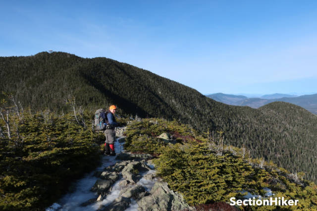
From 4000′ to 4500′, there are a series of switchbacks that climb up to Signal Ridge, an exposed section of the ridge overlooking Mt Lowell and Vose Spur below the summit. These switchbacks also had a lot of ice, mixed in with a few inches of snow, pretty much the only significant snow we encountered all day.
At 4500′, we ate a snack and layered up a little just before leaving the trees to cross the open ridge. I put on a wind shell and some gloves, but there wasn’t much wind. We crossed the ridge, gazing down into the abyss of Carrigain Notch. Once across, it’s another few hundred feet of elevation to the summit and the viewing tower at the top.
Once we reached the top of the peak, we climbed the tower and admired the view. Carrigain has the best views of any other 4000 footers and I picked out the distant peaks for Sandy. We could see Mt Bond and Bondcliff, South Twin, and Garfield, Owlshead, all of the Southern Presidentials, Mt Tremont and Owls Cliff, Greens Cliff, and the list goes on and on.
After a quick lunch, we put on our Hillsound Trail Crampon Pros and started our descent. The spikes on the Pros provided excellent traction and bit deep into the ice. I’ve been using mine for years and think they’re a great product. I doubt I’ll even use “real” crampons again. The ratchet-style bindings are much easier to use than a universal crampon binding and much more secure as well.

The sun went down by 4:15 pm when we were about three-quarters of a mile from the road. We turned on our headlamps and carefully continued down the trail. Once we hit the road, we hiked back down to the trailhead and the warmth of our cars. It’d been a long hike, but a quite satisfying gone. This was my eighth time up Carrigain, Barb’s seventh, and Sandy’s thirtieth. Yeah, really.
Route (out and back):
- Sawyer River Road – 2 miles (gated in winter)
- Signal Ridge Trail – 5.3 miles
- Total 14.6 miles with 4050′ elevation gain
I’ve heard that on a clear day you can see the other 47 4000 footers from the tower on Carrigan. It’s my favorite of all the 48.