 SectionHiker.com Backpacking Gear Reviews and FAQs
 I’m often asked whether Smartphone GPS Navigation Apps like Gaia GPS can work when they’re not connected to a cell phone network. Most Apple and Android Smartphones purchased in the past 3-4 years can operate in what’s called offline mode without access to to WiFi or a cell phone network. This is because GPS signals operate on a different network that can be received by the GPS-chip in your phone, even when you’re in power-saving airplane mode. You just have to activate the setting on your phone that allows your GPS App to access “Location Services” under the Privacy Setting on iPhones, or the equivalent on Android.

Offline Mode Preparation
For offline mode to work, you need to download the map you want to use for the area you plan to hike beforehand. It’s faster to download this data while you’re connected to a WiFi network, but it will also work over a cell phone network. You’re not actually downloading the entire map, but the region you plan to travel through. When you start hiking, you’ll load the region into the Gaia GPS app, so it will be resident in memory.
In Gaia GPS, this is an easy process. Open the app and navigate to the area where you plan to hike. Click on the rightmost “layer” icon on the top right and choose the map that you plan to use for your hike. I almost always use the USGS basemap although the USFS 2016 map has a little less clutter and can be easier to read (unless the clutter contains useful navigation information.)

Click “Done” one the map source window and return to the map view. Tap the circle icon with the plus in it to load the Download Maps dialog.
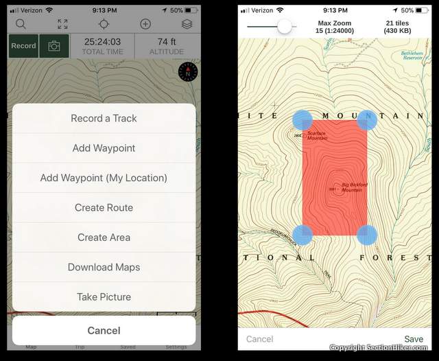
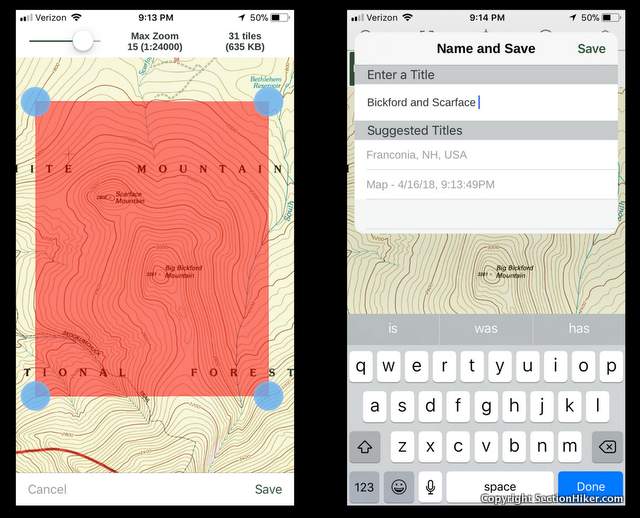
Use your finger to resize the area covered by the pink box, click save, and give it a name.
That’s all the prep you need to store a map for offline use.
At the Trailhead
When you get to the trailhead, start up the Gaia GPS app and load this map into your phone. You can be offline when you do it, since it’s already stored on your phone.
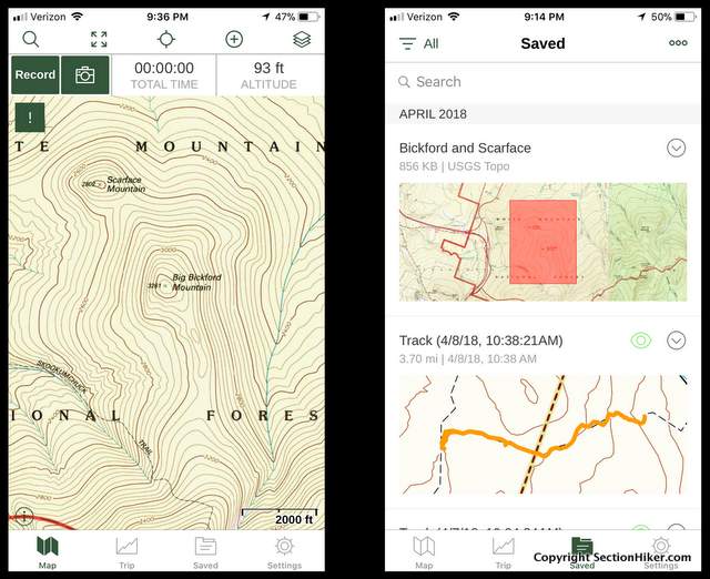
Bring up the map and click on the saved folder at the bottom of the screen. This will show you all the saved maps in the phone. You can collect quite a few and download far larger areas if you need to.

Click on the map you want to load. Then click on the three small circles in the right hand corner of the screen to bring up the “Show on Main Map” popup menu. Select that item and it will load the map for use.
That’s all there is to it.

See Also:
- Topographic Maps and Route Visualization
- Suunto M-3 D Declination Adjustable Compass Review
- Caltopo: A Great Online Mapping and Planning Tool for Hikers
Written 2017. Updated 2018.
SectionHiker is reader-supported. We only make money if you purchase a product through our affiliate links. Help us continue to test and write unsponsored and independent gear reviews, beginner FAQs, and free hiking guides.
Very helpful. I’ve been using Gaia but don’t hike anywhere near as frequently as you do, so I forget from use to use how to do this. I may find a way to save this blog post on my phone!
If you hike in the same area over and over, you can download the map for the entire area or break it up into regions and store that on your phone almost permanently. It’s takes up some storage, but cuts down on prep. Personally, I recommend the prep because it makes you think about your route more, which can be helpful even if you hike on trails all the time.
Good point about making it part of the preparation routine. I can almost pack my pack in my sleep, but forgot to do this for the Ozark Highlands Trail trip last month. Good thing it’s a well-marked trail with a great map. I’ll add this to my written and mental prep lists.
Important!!!’
Don’t know if this applies to Gaia, but the maps I load into Backcountry Navigator for offline use often don’t show the trail I intend to hike on them, so I need to go through the additional step of downloading a gpx file of the trail and/or waypoints so the app will overlay that onto the map as well.
applies to Gaia too if the trails aren’t on the map you download. Mine often are, but another good reason to do a little upfront planning.
I have struggled with this myself. How do you find the gpx files of trails (such as the Superior Hiking Trail). Perhaps you could lead me to an old post about which maps to use in Backcountry Navigator and where to find gpx files?
First link from google. https://shta.org/guide-book-maps-and-gps/
Another nice feature is, if you have a track installed, you can download the map for that track. Open tracks, select the track and tap “Download Map for Track”. Pretty slick!
I love Gaia. I usually download at the highest resolution. Gaia”s default resolution can be illegible for contour lines. Sometimes Gaia’s maps are not current so it’s good to check beforehand.
More and more I’ve been finding that the Gaia Topo (ft) map is a better choice because it includes more trails and is easier to read. Not always, but more frequently.
I really like the GAIA app also and use it with my paper maps. I also use the Maps3D app which is really handy.
One great feature of the GAIA app is the customer service. I was having trouble locating a map set for Isle Royale last year and they were very prompt to respond and get me a great trail map for my GAIA app.
You need to be careful to match the map Datum on your paper maps with Gaia in settings.
Thx Phil. Always wondered how this stuff works but was too embarrassed to ask. Don’t get me wrong. I have a state of the art flip phone with rotary dial. 1.8 ounces baby,,,,Oh yea !
I know someone just like you so I chuckle!’
Can anyone speak to the ongoing costs of Gaia GPS? In iTunes it says the app costs $19.99, but then elsewhere it mentions in-app purchases and subscriptions with no further information. Thanks.
I believe its 19.99, one time. More if you get pro access which is a web site tool, but lets you download extra maps which you may or may not use (and easy to do without).
Yep, I just went through this with them.
I thought I owed them money…not so, it’s a one time charge unless you want the Pro access. Pro access is called a subscription by them.
Bill
Thanks for the clarification.
Also, be sure to check your zoom level before you download if you want higher resolution maps. Higher resolution = more map tiles = more storage, though.
As follow up, Gais just released a new version for IOS that, IMHO is a major step back, so much so that I recommend against purchasing the app. First, they changed to a subscription model (without asking for permission, by the way). Sure, they provide registered users with an extended trial period (in my case, two years), but after that, plan on shelling out $10 per year for what was previously an unlimited subscription. In addition, the new version omits a couple of key features. There is no longer a way to download a map along a track, one of the most useful features of the old app. In addition, they eliminated the swipe gestures and revamped the saved data menu that is inferior to the previous version. If you have the old version installed, you maybe able to keep it, since I opted to install the new version, thinking it was a simple upgrade. That being said, I would expect, over time, the old version will become obsolete and/or you will be jammed into the new version. Bad form and a stick in the eye to ll the people who bought the old app.
Just upgraded my Gaia subscription from Member to Premium to use the new Satellite Topo base map layer. Can’t wait to try it out this weekend.
I can’t download map on my Gaia app on my sndroid phone. Do I have to sign up and pay?
Probably.
Hi,
I’m using the free version of the GAIA App. I have hiked several times using the apps but all the recorded routes are overlapping one another. How do I refresh the map for new hiking route the next time.
Thanks
Turn off the display of your tracks. Tap on the track to bring up the settings to do this or google for directions. That irked me too until i figured it out.
I just bought a membership to Gaia, but i can’t seem to use the offline maps effectively – is it supposed to be able to locate and track us on an offline map? I just tried using it on a hike outside of any signal, but it had no idea where i was, so it had no idea if/when i arrived at the trail, and where i was on the trail.
or are users supposed to just use it like a static paper map, and we are expected to find our location on an offline map manually?
did you download a map and then load it?
I use on a Samsung phone so need to provision that yours may well be different if on an iPhone.
If you paid for the subscription you can select an area that you want it to download. The bigger the area the bigger the file and the longer to download (you’ll want to do this while on Wi-Fi). I downloaded the whole state of NH and while it was a very large file, storage is cheap.
From there when you get into the field you should be able to open the app and it should give you a pointer to show you exactly where you are on it. I always flip my phone into airplane mode so it doesn’t burn the battery looking for cell service while hiking and it just uses the GPS to keep my location plotted on the, already downloaded, map.
It’s quite possible you also haven’t allowed the GAIA app to use your location.
I find that essential steps are omitted. For instance, it says in Offline Preperation that you “open the app and NAVIGATE to the area where you plan to hike. Just exactly how does one NAVIGATE? What does that mean?
HELP!!!!
Touch your finger to the screen and drag it until the area where you plan to hike is displayed.
The phone app opens to the last map/zoom you had it open to the last time you looked at it. If you were using it in Florida and then went to Utah and opened it, it would show you Florida. You can use your finger(s) to expand/contract the map and move it to different locations. Provided you have a GPS signal your present location will show as the yellow compass arrow on the map.
You can also click on the circle with 4 hashes coming out of it at the top of the screen (sort of looks like a compass) and it will bring you directly to where you are at that very moment.
I find the web version of GAIA better for actually researching and charting out hikes (distances, elevations, shelters, etc) and you can save a track on the computer which will synch with your phone.
I am confused by something. I downloaded Gaia in February to try it out before buying. It says that with the free membership you can’t use maps offline, but so far it seems that the maps are still available offline, even if I turn off the app and reboot the phone. Why is that?
Suggest you contact GaiaGPS and ask them.
I have hiked using the Gaia program on my phone. It was great! It located me and then shows a line of where I was hiking so I could see where I had been. Then about the fourth hike it quit showing my trail (I bushwhack and don’t use regular trails)
So now can’t see where I have traversed. Anybody know if I have turned something off?
I only have experience with the Android version – so we’ll go with that.
Are you recording the hike? Hitting the button to record at the start of the hike then saving it at the end? If you’re not recording it, it won’t show the track you’ve been traveling and just shows the chevron as to where you are.
Beyond that I know how to hide a track that’s been recorded/completed but not of any option to hide the breadcrumb trail while you’re actually recording it.