The Howker Ridge Loop is a 2 day, 18 mile loop that climbs all of the peaks in the Northern Presidential Range: Mounts Madison, Adams, and Jefferson. The route passes several unusual geological features including small peaklets known locally as Howks, an alpine tarn called Star Lake, and towering rock spires called castles. After climbing Madison and Adams, we recommend spending the night at one of the Randolph Mountains Club’s huts or campsite, close to treeline. The next day begins with a short hike to Edmands Col before climbing Mt Jefferson and then a looping descent past numerous waterfalls to the valley below.

Rating
B5 - Toggle Open for Key
Distance
A: Less than 15 miles in distance
B: 15-20 miles
C: 20-25 miles
D: 25-30 miles or less
E: more than 30 miles
Elevation Gain
1: 3000 ft or less
2: 4000 ft or less
3: 5000 ft or less
4: 6000 ft or less
5: over 6000 ft
Distance/Elevation Gain
18 miles w/6600′ of cumulative elevation gain
White Mountain 4000 Footers
- Madison
- Adams
- Jefferson
Recommended Duration
2 days
Season
June thru October
Permits Required
None.
Regulations
Backcountry Camping Regulations for the White Mountain National Forest.
Weather Cautions
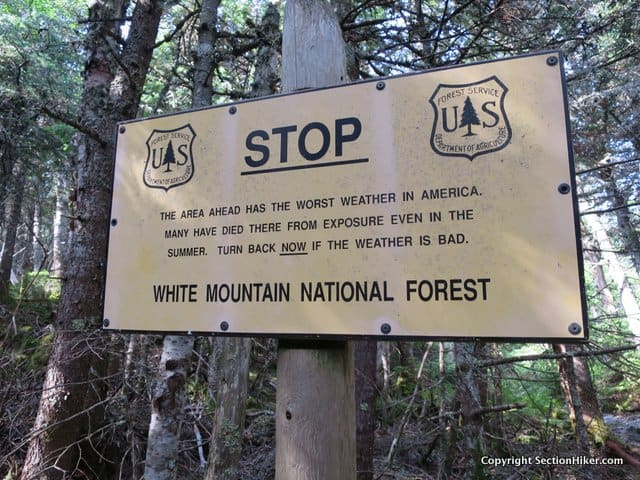
This route is sensitive to seasonal weather which can make it hazardous. Most of this route is above-treeline and travels across exposed terrain where high wind, cold temperatures, fog, thunderstorms, lightning, and hail storms are common during the summer months.

The best way to avoid difficulties or injury is to time your hike to avoid poor weather (by checking the Weather.gov and Mt Washington Observatory Higher Summits Forecasts) and to bring proper clothing, equipment, and navigational aids. If you’re inexperienced with above-treeline backpacking, I’d also recommend bringing a more experienced friend or guide to show you the ropes.
Trailhead Directions
- Randolph East Trailhead; easiest access is from Rt 2, just south of the Appalachia Trailhead. Turn left onto Pinkham Notch ‘B’ Rd and look for the parking lot on your right.
Maps
The Appalachian Mountain Club publishes the best maps for the White Mountains and I’d recommend buying the complete AMC White Mountain Waterproof Map Set. It contains three waterproof maps (2 regions per map) although you only need carry one or two on any trip. I also use GPS apps for navigating, but these maps contain relevant trail, shelter and topographic information that is often not included in electronic maps. More detailed trail descriptions can also be found in the AMC White Mountain Guide, which is considered the hiking bible for the region. It includes detailed driving directions to remote trailheads and is indipensible for navigating to them, especially when you're out of cell tower range. Take photos of the pages you need using your phone for easy reference, instead of carrying the entire book with you on hikes.Navigation Apps
I also recommend purchasing a GPS Phone App such as Far Out's White Mountain National Forest Guide, which lists most of the trails, trailheads, shelters, campsites, views, and water sources in the White Mountains National Forest. GaiaGPS is another GPS Phone App, which is stronger in terms of topographic map coverage for the White Mountains but does not have as much information about trailheads, shelters, campsites, views, and water sources. I use both frequently.Trail Sequence
The route follows the following trails in sequence.
- Howker Ridge Trail – 4.1 miles
- Osgood Trail – 0.8 miles
- Star Lake Trail – 1.o miles
- Lowes Path – 1.2 miles
- Gray Knob Trail – 1.2 miles
- Randolph Path – 0.7 miles
- The Gulfside Trail – 0.2 miles
- Jefferson Loop – 0.3 miles
- Castle Trail – 1.5 miles
- The Link – 5.0 miles
- Sylvan Way – 1.0 mile
- Randolph Path – 0.7 miles
Scenic Highlights
The following list provides cumulate distances on the route to each view or landmark
- First Howk – 2.7 miles
- Fourth Howk – 3.5 miles
- Mount Madison Summit – 4.4 miles
- Madison Hut – 4.9 miles
- Star Lake – 5.2 miles
- Mt Adams Summit – 5.9 miles
- Thunderstorm Junction – 6.2 miles
- Mt Abigail Adams (Adams 4) -6.6 miles
- Gray Knob Cabin & The RMC Camps – 7.4 miles
- Edmands Col – 9.3 miles
- Mt Jefferson Summit – 9.6 miles
- The Castles – 10.6 miles
- Cold Brook Falls – 16 miles
Camping and Shelter Options
- USFS Valley Way Campsite (Free) – Located on a short spur off of the Valley Way Trail 3.1 miles from the Appalachia Trailhead.
- AMC Madison Spring Hut ($$$) – Advance reservations recommended
- RMC Crag Camp Hut ($) – Walk-ins only. Crag Camp is located about 1 mile northwest of Thunderstorm Junction, near to Gray Knob and The Perch. The easiest way to reach all of the RMC shelters from Thunderstorm Junction is to follow Lowes Path to treeline and to then follow protected paths to the destination of your choice. The Log Cabin is also located off Lowes Path but with more elevation loss.
- RMC Gray Knob Hut ($) – Walk-ins only. (see above)
- RMC The Perch Lean-to and Tent Platforms ($) – Walk-ins only (see above).
- RMC The Log Cabin Lean-to ($) – Walk-ins only (see above).
Water
Natural water sources are plentiful in the White Mountains although you may need to descend to them from ridgelines along side trails if you run short. In any case, carry a detailed topographic map with you and don’t rely on the overview map provided with this trip description to find water sources.
On the Trail
This route starts at the Randolph East parking lot, which is down a short side road called Pinkham B, just east of the famous Appalachia Trailhead on Rt 2. At the trailhead, follow signs for the Howker Ridge Trail, which runs through hardwoods and past several small waterfalls before it begins to climb up the east ridge of Mt Madison. The RMC or Randolph Mountain Club maintains many of the trails and shelters that you’ll use on this hike. They’re a small local club with a storied history of trail building in the Northern Presidentials and worth supporting. You also get a much reduced nightly rate at their shelters and camps if you’re a member (click for membership).

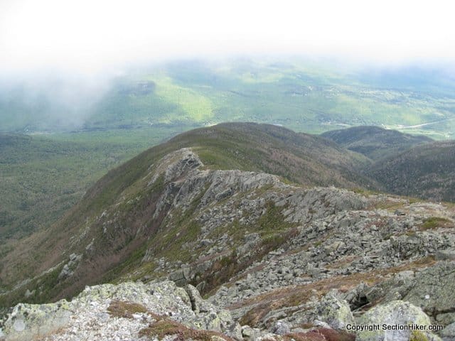
After passing several waterfalls and cascades, the Howker Ridge Trail begins climbing the northeast ridge of Mount Madison with many ups and downs. There are four howks as they’re called, or peaklets on the ridge, which are look like rounded humpish hills, when you’re looking down on the trail from above.

The first of these occurs after 2.3 miles and the second at 3.0 miles. The Pine Link Trail joins the Howker Ridge Trail on the left and the two coincide for 0.3 miles, climbing to the third howk which has a good view of Madison. The two trails diverge again and the Howker Ridge Trail continues to climb, passing the fourth howk at mile 3.5 (4315′). The trail soon ascends above treeline where it is completely exposed to the wind and weather. Continue climbing, before turning SW onto the Osgood Trail which follows the ridgeline over the Mt Madison summit.

The view from Mt Madison is quite spectacular and affords descent wind protection if you hunker down behind the rocks near the summit sign. Looking to the southeast, you should see a long, curving, boulder-covered ridge descending to Pinkham Notch. This is also the Osgood Trail, but headed in the opposite direction from where you’ll be going. Turning to the southwest is Mt Adams, the second highest mountain in the Whites, on the other side of the Madison Col. Beyond that in the distance, you can just make out Mt Jefferson as well.

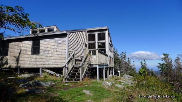
From the Madison summit sign, follow the Osgood Trail west to the AMC’s Madison Springs Hut. Located in the col between Madison and Adams, the hut is a good place to top off your water bottles, use the rest room, or buy a snack. Day hikers are welcome to come inside even if they’re not overnight guests. The hut is also a good place to check on the wind speed, barometer, and latest forecast, which is updated every morning.

From the hut, follow the Star Lake Trail a short distance passing a small alpine tarn (pond). While it usually has some water in it, the level varies by season and weather conditions. Bear right past the tarn and continue following the Star Lake Trail which scrambles, steeply at times, to the summit of Mt Adams. When you crest the peak, be prepared for a blast of wind from the prevailing northwesterly prevailing winds that scour this exposed summit. Like Madison, the views from Adams are sublime. Look down into the Great Gulf, the great glacial cirque at the foot of the northern Presidentials ,and across it to “George”, as Mt Washington is known locally.

From the Adams summit, follow the Lowes Path for 0.3 miles across a boulder field to the huge cairn at Thunderstorm Junction, which is visible below in clear weather. This section of the Lowes Path is marked with rock cairns and must be followed carefully.

When you arrive at Thunderstorm Junction, I’d recommend calling it a day and heading down below treeline to stay at the RMC’s Gray Knob or Crag Camp Self-Service Cabin or The Perch Tentsite for the night. All three of these options are far less expensive than staying in the AMC’s Mountain Springs Hut, but are also self service.

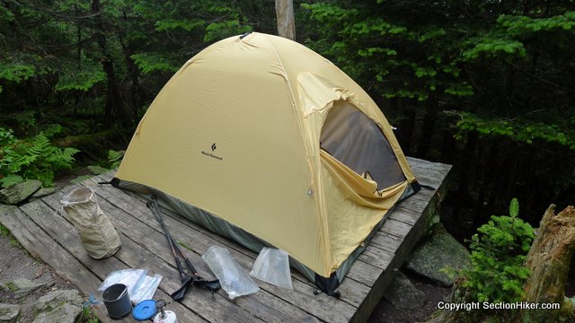
Gray Knob is a pleasant self-service hut to stay at overnight with mattresses on the floor and a small eating area. The RMC’s Crag Camp, a similar hut, is a short walk. If you prefer to camp, the RMC’s The Perch Campsite has a three-sided lean-to and tent platforms that are also available. All require payment of a small overnight fee, and now accept Paypal, in addition to cash. See the shelter description links above for details.

All of the RMC Huts and Campsites can be reached by continuing along the Lowes Path for 1.2 miles. This trail is marked by quartz-topped cairns and best hiked in daylight. There is a small rock scramble 0.3 miles below Thunderstorm Junction over a sub-peak of Mt Adams called Mt Abigail Adams (also called Adams 4 on older maps), before the trail continues to a junction with the Gray Knob Trail and The Perch Path. Both the Gray Knob and Crag Camp Cabins are located along the short Gray Knob Trail, while the Perch Path leads to The Perch lean-to and tent site platforms.

Resume the next morning by following the Perch Path almost due south, towards Mt Jefferson. Turn left at the Israel Ridge Path Trail Junction. In 0.4 miles, the Israel Ridge Trail meets the Randolph Path, and the two trails coincide for 0.1 miles. Continue along the Randolph Path for another 0.7 miles until its junction with the Gulfside Trail in Edmand’s Col, a sheltered windbreak in the lee of Mt Jefferson.

Once the site of a rescue cache, Edmands Col has a plaque dedicated to J. Rayner Edmands, one of the great trail architects of the interconnected White Mountain Trail system. When hiking in the Northern Presidentials, you can still see evidence of his handiwork today. A stickler for precision, he built many of the major trails using carefully fitted stones, so they’re easy to follow across the rough, rock-strewn terrain.

From Edmands Col, turn right onto the Gulfside Trail (bearing southwest) and follow it for 0.2 miles, turning right onto the Jefferson Loop Trail. Follow it for 0.4 miles, passing a large rock cairn, just below the summit which is a short scramble to the summit sign. Jefferson is one of the windiest spots in the Whites, short of the Mt Washington summit, so hold onto your hat, lest it blow into the Great Gulf.
Descend to the large rock cairn, following the Jefferson Loop Trail to the Castle Trail, which runs down the mountain’s north side. Like the Howks, the Castle Trail is topped by rocky outcroppings known as castles, which tower above Castle Ravine below. There are two castles, just below 4500′ of elevation.

You’ll dip below treeline after the second castle, near “The Link” trail junction. Turn right onto The Link, which is a long looping descent around the back of the Northern Presidential range. It passes through hugely varied terrain, beginning with steep descents, waterfalls, and several easy water crossings, followed by forested hardwoods. The Link is fairly well blazed and easy to follow, but seldom hiked by day hikers, so less heavily used than the trails running up to the peaks.
Follow The Link for 5.3 miles, passing many trail junctions, until you cross over the pretty wooden Memorial Bridge, below Cold Brook Fall. Jog right onto the Sylvan Way, a pretty forested path for 1.0 mile, before turning left onto the Randolph Path for the remaining 0.7 miles back to the Randolph East parking lot and the end of the route.
About the author
Safety Disclaimer
This trip plan can not alert you to every hazard, anticipate your experience, or limitations. Therefore, the descriptions of roads, trails, routes, shelters, tent sites, and natural features in this trip plan are not representations that a particular place or excursion will be safe for you or members of your party. When you follow any of the routes described on SectionHiker.com, you assume responsibility for your own safety. Under normal conditions, such excursions require the usual attention to traffic, road and trail conditions, weather, terrain, the capabilities of your party, and other factors. Always check for current conditions, obey posted signs, and Backcountry Camping and Wilderness Area Regulations. Hike Safe and follow the Hiker responsibility code.Click for More Free 4000 Footer Backpacking Trip Plans
- Presidential Traverse
- Pemigewasset Loop
- Bonds Traverse
- Twins/Bonds Traverse
- Kilkenny Traverse
- Carter Wildcat Traverse
- Southern Presidentials Loop
- Moriah Loop
- Kate Sleeper Loop
- Howker Ridge Loop
- Isolation Loop
- Mad River Notch Loop
- Thirteen Falls Loop
- The Desolation Loop
- Willey Range Loop
- Firewardens Loop
- Carter Moriah Loop
- Cannonball Loop
- Tunnel Brook Loop
- Carter Dome Wild River Loop
- Mt Carrigan and Mt Nancy
 SectionHiker.com Backpacking Gear Reviews and FAQs
Try one of these.
https://sectionhiker.com/backpacking-white-mountain-4000-footers-guidebook/
I’d recommend the 13 falls loop. Take it as slow as you want. I have a couple of more trip plans in the pipeline that will be published soon.
Or check out my personal trips (not guidebook ones) and see if any appeal.
https://sectionhiker.com/category/trip-report/white-mountains-2/backpacking-trips/
Did this as a day hike/run yesterday and it was beautiful! I found the directions and distances on this article to be very accurate, so thank you for that! I wouldn’t consider this trail to be great for running because most of the terrain is challenging to move over quickly. Also, I wouldn’t recommend this trail for dogs (luckily I didn’t bring mine). The Link trail is quite unmaintained as of now, with many spots grown over and lots of debris on the path. As long as you follow the signs you will find your way back to the parking area! The Madison through Adams area was pristine in terms of views. It was a challenging day but I’m really glad I did this trail!
If you’re in good shape, you should be able to attain a 1 mile an hour pace on the climb. The trail takes you up over Mt Madison, which I would advise doing in daylight unless you want to break a leg (it’s covered in boulders). The valley way campsite, which is the closest campsite is about 5.5 miles up. It’s first come first serve, so if I were you I’d pick a weekday to hike it or leave MUCH earlier in the day. There is simply no other place to camp for miles given the slope angle and tree cover in that area. And camping above treeline is illegal.
What about doing the route the reverse way – if, for example, one doesn’t live near the White Mountains (sigh!) and has to drive a ways on the first day? In other words, on day one hike to The Perch (maybe by Randolph Path or some other reasonably direct route), on day 2 summit Jefferson, Adams, and Madison, returning by Howker Ridge? Or is that too much for a second day?
Love this site! Thanks.
The problem with the Perch and all the RMC cabins is that they’re closed through 2020. You could camp at the Valley way USFS campsite, however, which is probably better than the Perch for these peaks. From Jefferson you could take The Link Trail back to the Appalachia Lot. Makes it along day, but it’s mostly downhill. :-)
Howker is really best enjoyed going up although you can go down it.
The fastest way up Adams and Madison is the Airline while the easiest is probably Valley way.
Thank you, Phillip for this resource! Planning on doing this loop in a week and have two questions. 1. With RMC campsites closed this summer, where would you suggest camping to break up the hike best? 2. Are there swimming opportunities along this loop/are Star Lake or Cold Brook Falls suitable? Thanks!
Camp at valley way. You wouldn’t want to get into Star Lake. Cold brook falls is a possible though.
Thanks again for making this resource available! I took the Howkers loop and extended it to two nights over the holiday weekend and it was amazing. Going up Howkers sure beats the other paths to Madison. I mean, waterfalls, moss and duff covered trails? Steep, yes, but you still have to gain 4K feet somehow…
Loved staying at the RMC Perch tent site, though it filled up by dark on Saturday night. Fortunately I got there early and had been hanging out much of the afternoon.
For day two, I summitted Jefferson and Clay, before heading north on Gulfside to Airline and down to the Valley Way tent site via Upper Bruin. What a spectacular ridge looking deep into King Ravine! Again, made it to camp by mid afternoon.
Hiked out the third day via Lower Bruin, Brookside and Kelton, which was even less traveled than Howkers. So many waterfalls I lost count. This is my last White Mtns hike for the year, but I’ll definitely be back, starting as always with a study of your loop hikes.
Glad you had such a great time…and you’ve only scratched the surface!