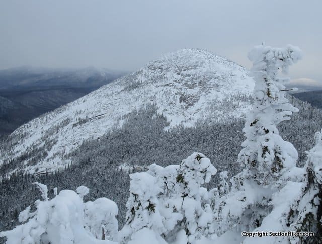
We triggered a human generated avalanche on North Percy mountain, breaking through wind slab that was sitting on a layer of ice. It wasn’t a huge slide, but I could tell that it rattled that guys who triggered it. No one was hurt, but it served as a reminder of the hazards of remote winter hiking. North Percy is a bald dome in New Hampshire’s Nash Stream Forest, north of the White Mountains, and ripe avalanche terrain.
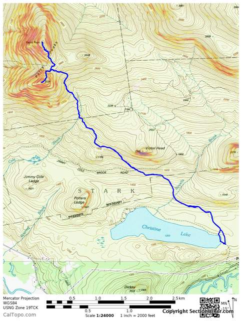
After getting home, I downloaded our track from the Gaia Navigation smartphone app which I’d used to track our route up North Percy to check the slope angles of our route. Avalanche terrain usually has a 35-45 degree slope angle, which can be viewed using Caltopo.com slope gradient visualization layer. The key for the slope angles is listed in the upper right hand of the graphic below. The dark red and purple shaded areas are the most prone to winter avalanches.

The trail up North Percy is obfuscated in winter, buried under snow and ice, and there aren’t any cairns, so we climbed it on a route of our own making through snow drifts and over rotten ice-covered ledge. But judging from the map of our track shown above, we hiked up terrain which should have mostly been safe from slides. Still I’d wish I’d plotted the route in Caltopo before hiking this trail and not after. I’ve hiked North Percy before in three season conditions and the thought of winter slide potential hadn’t even crossed my mind. Live and learn. Complacency is a human factors hazard in winter.

We also climbed South Percy (3234′), but that route is covered in trees and doesn’t have the open ledges that North Percy does. While the route up to the summit was shorter, it felt a lot harder than the climb up North Percy – probably because there was so much snow and we were so beat.

It had been a hard hike, a hard snowshoe to get to the col between North and South Percy following the Cohos Trail. We’d started at frozen-over Christine Lake, outside the tiny village of Stark, north of Mt Cabot and the Kilkenny Region of the White Mountain National Forest. We had to approach the Percy Peaks from this direction, because Nash Stream Road is closed in winter.
The first part of the hike had been easy, following the Old Summer Club Trail which is packed out as a snowmobile route, until we reached the Cohos Trail. We strapped on our snowshoes there and started plowing through the snow, which got deeper and deeper (1-2 feet deep on top of a base) as we climbed the ridge up to the Percy Peaks. The snow was the consistency of sugar, so it still stayed puffy after it had been broken out. There were six of us in total, just enough to alternate taking point, but it was exhausting nevertheless.

Still we had a very strong group of experienced hikers, all from the Random Hikers Meetup Group, in my opinion the best organized hiking group in the White Mountains Region. I’d hiked with half of the people in this group previously, but there were a few others that I got to meet and know better on this trip.
Thankfully, this section of the Cohos is well blazed, so we could follow the trail fairly easily. As we climbed the snow got deeper and deeper and we started encountering blow downs blocking the trail, along with spruce traps, voids that are easy to fall into, around them. I fell in one down to my waist and it was exhausting getting out. Still we slogged on until we reached the col between the peaks and had a long food break.

Once we started climbing North Percy, my fatigue vanished, replaced by the awe I feel when I climb up above treeline. North and South Percy Peaks are both beautiful to climb with excellent views to the north and south. For example, we could see the windmills on Dixville Peak from North Percy, Goose Eye Mountain in Maine, and Carter Notch in New Hampshire. You just don’t get views like that anywhere else.
After we descended South Percy, we hiked back out the way we’d come – moving much faster, to try to get back to Christine Lake before sunset. We made it back to the cars just in time, at 5:30 pm, grateful for an extra hour of sunshine as the winter days get longer.
Total Distance: 9 miles with 2700′ of elevation gain.

Written 2017.
 SectionHiker.com Backpacking Gear Reviews and FAQs
Nice report and glad everyone is OK! Did you report the slide to MWAC? They collect info on avalanches outside of the ravines.
It was a very tiny slide, no more than 20′ diameter and soft. It broke right around me and slide less than 20′ downhill. I’m not sure it qualifies as something to report. If the material on the slide had been deeper, harder, or more consistent there might have been a danger factor.
Like Paul says, this was a small slide. I just wanted to alert people to the fact that slides can and do occur in the Whites and NH outside of Tuckerman and Huntington Ravine which have forecasters. Backcountry Skiers and climbers are well aware of this, but Avalanche awareness among hikers is virtually nonexistent in my experience.
Nice trip report… and good reminder to be familiar with best routes and approaches when going up steep terrain. Well done!
If you had examined the slope angle on Caltopo before this hike, what would you have done differently, since it appears from the map that was included in the post that your hike really take you into an avalanche prone slope?
Great question. I think I would have been more aware of a potential issue.
We could have exercised more discipline in keeping the group together as we headed up the hill. That track you see is my route up the hill, but others walked a separate line. As it was, we were very spread apart and stacked, so if a slide falls, it wipes out the person below.
Since most of us also carry Gaia, we could have whipped it out and made sure we were on the flatter section.
We could have also performed hasty tests of the surface – not as good as digging a pit but still useful.
Hello, I noticed you use Gaia GPS. Is it pretty easy to use with Caltopo? Im searching for an alternative to Avenza PDF Maps. I like Avenza because I can load my Caltopo map (my preference, shows all the old trails) but their pricing is prohibitive.
I usually go from Gaia to Caltopo and that’s trivial. I’m pretty sure you have to go through GAIA’s web portal to import gpx files into your routes. It’s been a while since I tried. But you might want to verify that. They have a planning tool similar to Caltopo online, but it’s much harder to use with a laptop in my opinion.
Glad u all made it out alive and in one piece. . . . Kinda wish, though, that people would not talk about their mishaps on the ‘net, since it [ can ] serve to “spotlight” a very nice area in a not-so-favorable light.
Percy is a much bigger peak, when u are on it, than what it looks like from a distance ! I have done it, numerous times, on skis and snowshoes [ both for the same trek ] , in midwinter, and it NEVER has proven to be a casual day out. . . Always packing a punch, especially as u get up to near the treeline and certainly above that point.
It has a serious alpine feel to it, no question, and some of the more direct routes on the face itself can rival the material on Mt Washington [ and by direct routes , we mean out in the open and not to be touched unless the conditions happen to allow it , which is not too, too often ] .
At this time i am living and working in Thailand, and have been here since 2014. I would ordinarily do anything to just return home and climb, ski and generally resume my former life , but I am ensconced in teaching here, for now, so I must duke it out with the Land of Smiles’ treacherous roads and fast traffic until the day comes when my mission here is done.
I can say that skiing the Percy trail, as a semi-open glade run, is a frickin’ amazing experience when the conditions are prime ; I never have seen anyone else doing it, but i have heard of a few souls giving it a shot now and then. The snow-covered road back to the gate has always been good for a thrill, especially after dark, with the eerie howl of snowmachines in the distance. . . . Skins are a plus, definitely, and on a moonlit night the crisp surface of the skiDoo-packed road is not to be outdone !
I plan on my first winter ascent of North Percy this week. I stumbled across this blog and found it quite interesting. I’ll be solo with my dog Shay, so I will take Percy as it comes, plan on walking Nash Stream road and taking that route.