
The Maine Appalachian Trail is a tough, tough place to hike. There are lots of mountains and mud and rocks and roots, but the weather is just so unpredictable and nasty!
I got a taste of that (again) when I backpacked from Stratton to Rangely for 4 nights and 3 days, last week. This is a very tough section of the trail with a lot of above treeline exposure and steep climbs up North and South Crocker, Spaulding Mountain, The Horn and Saddleback Mountains.
I’d hoped to go even farther than Rangeley on this hike and finish all of the remaining 79 miles of the AT I have in Maine, but I got off the trail after 32 miles due to violent thunderstorms, hail, high winds, rain, and a possible tornado. Being a section hiker, I had a hard deadline (my wife’s birthday) to finish this hike by and there was no way I was going to make it with a 2 day bad weather delay. That’s basically what it boiled down too.
Rangeley turned out to be a good town – basically the only town – to get off the trail and get a ride back to my car down in Grafton Notch, something that only happened because of a little trail magic.
Here’s the tale:
You Can’t Get There From Here
I met Hikerboy at Grafton Notch where we’d agree to meet our shuttle driver, Sue from the Stratton Motel. She’s super reliable if you need a shuttle, but a bit on the expensive side. Still, AT shuttle drivers can be a bit sketchy, so it’s nice to have someone you can count on. (Her dog is named Knucklehead and he’ll drool on your leg if you sit in the back seat.) This is the second time I’ve used her shuttle services: she’s nice and she’s prompt.
It was a two hour drive from Grafton Notch to the Stratton Appalachian Trail trailhead. There aren’t many roads in Maine and the common refrain is “you can’t get there from here.” The mountains and lakes and lack of paved roads make direct routes difficult, so shuttles can be rather expensive. I’d delayed the start of my trip by 3 days so I could split the cost of the shuttle ($80 dollars each) with Hikerboy, but on hindsight, I wish I’d had the three days of sunny cool weather before we met up. Roll of the dice, I guess.
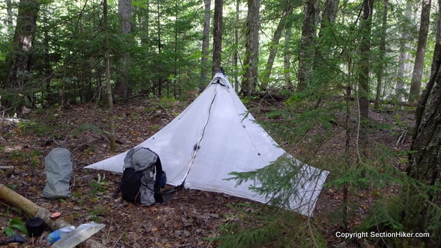
We arrived at the Stratton trailhead at 3:30 pm, a little late in the day to go far. I’d hoped to hike south and up North Crocker Mountain a few miles to stealth camp next to a spring marked on my map and in the AT Guide, but Hikerboy wanted to hike north 2 miles instead, and camp at Cranberry Stream Campsite because it had a more reliable source of water. Sunset was at about 6:45 pm and I decided to go with him. Good thing I did, because that spring was dry when I hiked past it the following morning!
While the water at the Cranberry Stream Campsite was better, the campsite was terrible, and all of the pitches were slanted or had roots running through them. I hunted around a bit deeper in the woods and pitched up on a bed of softer leaf litter that was just big enough for my Duomid. It had been slept on before, but not that much.
First Frost
It was cold that night, dropping down to 33 degrees. Some of the farmers in the valleys even experienced frost on their crops. I’d come prepared though with my warmer 20 degree bag and slept comfortably that night, although I had nightmares, something that happens at the beginning of hikes when I’m not tired enough and my city stress hasn’t properly drained.
Hikerboy told me that there was a big pile up of thru-hikers down south in Gorham, New Hampshire, with people waiting for the cold weather to clear out so they could continue their hikes in comfort. I bet they were surprised when the heavy rains came, on a very rough part of the trail through the Mahoosucs and north to Grafton Notch. I hope no one was hurt.

The Early Bird…
I was up at 5:00 am the next morning and on the trail by 6:30 am after lying around and zoning until first light at 5:40ish am. I treasure that 30-40 minutes between the time I wake up on hikes and the time I get out of my sleeping bag. I don’t think about anything at all, but I am awake. Hard to explain really. It’s time I never have at home.
Hikerboy was just getting up to make breakfast when I said goodbye and that was it. I never saw him again, but I’m sure he’ll drop me a line sometime.
I was hoping to make tracks that first day and get into the hike. I wasn’t completely sure where I was going to camp that night but there was a shelter 15 miles south that I figured I try to get to. I backtracked over the two miles I’d hiked north the previous evening, crossed Maine 27, and headed up North Crocker Mountain through dense forest. The autumn leaves were just beginning to turn, especially the softer woods like birch and beech.

The climb up North Crocker was easier than I’d expected. It is a 4000 footer, which is a big mountain by Maine standards. I climbed 2,750 feet up to the summit spread out over 5 miles, so not too bad of a climb, but my heart was definitely pumping. I was carry 6 days of food with a total pack weight of about 30 pounds including two liters of water. I felt it. Cold weather is here along with heavier pack weights.
I met a trail maintenance crew on the trail from the Maine Conservation Corps building water bars. They were working a month-long shift with 9 days on the mountain, 5 days off, then another 9 days on. One of the women on the crew said it was hard because the weather had been so cold and the wind cut right through her. You have really respect these people. The work they and MATC do maintaining the Maine AT is just unbelievable. You’ve never seen such amazing stonework. Their work will outlive all of our urban skyscrapers.

I had a snack and then continued to the South Crocker summit a mile away. Though slightly lower, South Crocker has much better views and interesting rock slides on its southern face. The descent is also very steep, plunging 2000 feet in two miles.
It was here that I encountered my first hiker of the day, a fellow peakbagger who was climbing the New England Hundred Highest and planned to bag North and South Crocker, plus do the Reddington Bushwhack all in one day. Ambitious! He’d been on Mount Sugarloaf the previous day, dressed in full winter gear, because the temperature had been so cold and the winds so high.
Got Milk?
I was out of water by the time I got down South Crocker, so I filtered another two liters at the Crocker Cirque Campsite stream and ate a bowl of cereal out of a Ziploc. I kid you not! It ate a half cup of Muesli mixed with a cup of dry low-fat milk rehydrated with cold water. That really hit the spot ~ about 500 calories of raw nuts and dried fruit. Having milk on a backpacking trip was a first for me and a keeper.

Leave No Trace is…
Descending further, I crossed the Carrabasset River walking over a board where there was supposed to be a ford. I’m not too keen on ad hoc solutions to avoid getting your feet wet when they spoil the wilderness feel of a walk. The board was probably put there by a hiker and not a trail maintainer. Oh well. I’d see the same remodeling theme repeated at other marked fords where people had moved stones to fill in stream crossings on my walk farther south. Together with Trail Angel trash at trail heads and candy wrappers on the trail, Leave no Trace is dead or at least dying on the Maine AT, I’m afraid.

Spaulding Mountain
The next peak on my route was Spaulding Mountain, which is massive and almost 10 miles in length. I had another steep climb, over 1000 feet in less than a mile, to get up onto its long summit ridge. This climb was also very exposed with little tree cover. I knew that thunderstorms were forecast for that evening so I was on guard for signs of bad weather, particularly lightning, having had one close call earlier this summer on Mount Madison in a hail storm down south in New Hampshire.
As the afternoon progressed, I was getting tired, and while there were plenty of open woods to camp in on Spaulding, there wasn’t any water. I had to keep hiking until 5:30 pm until I got to the Spaulding Mountain Lean-to before I could stop. It was a big day with 15 miles and 5,000 feet of elevation gain in 10.5 hours. Not bad for an old man, and I wasn’t even sore the next day. Remarkable. My workouts must be working….

Miraculously, I was the only person in the shelter up until just before night fell and Sea Biscuit arrived to share the lean-to with me. He is a microbiologist from Connecticut who is getting married on September 28th and needed to average 21.8 miles per day on the rest of the trail northbound to finish before his wedding. Nice guy!
While somewhat dilapidated – porcupines had been at the boards to eat the hiker sweat – this shelter was remarkably clean inside, freshly swept out although there wasn’t a broom in sight. It also had a remarkably good spring-fed water source and the water tasted great, even though I filter everything anyway. I’d taken my favorite spot on the right wall of the shelter when I’d arrived because it lets me keep stuff beside the edge of the shelter and my sleeping bag, like a little private shelf. No evidence of mice, either.

I cooked up dinner on my wood stove, some Mountain Gruel, and took care of my camp chores such as water filtering so I could leave quickly the next morning. I also hang my Ursack each night, which I do even when I stay in a lean-to because I figure it prevents mice from attacking my food. Seems to work too.
I went to sleep at dark, expecting a thunderstorm that night.
Thunderstorms above Treeline
I was a little obsessed about thunderstorms on this hike because there were so many places on my route where I was fully exposed to the elements. Getting struck by lightning is a real danger when you are on top of a rock dome, holding a pair of aluminum hiking poles, and hiking with an aluminum stay in your backpack. While I know hikers who have been struck by lightning and lived, they’ve never really quite been the same afterwards.
Perhaps I have been over-sensitized to the danger of thunderstorms by hiking so much above treeline in the White Mountains, but it is terrifying to be in the open on a mountain when lightning strikes nearby. I go out of my way to avoid it because I know what it’s like.
Day Two
I was up early again the next day because I know from experience that thunderstorms are most likely to occur after 3 pm when the sun has had a chance to heat up the clouds. If you want to avoid thunderstorms, get up early and get as much of your mileage done as early in the day as possible. I learned this hiking the Long Trail in 2008 and it’s why my trail name is “Earlylite.”

One Big Mountain after Another
If you look at an elevation profile of the southern part of the Maine Appalachian Trail, you’ll see that the route goes up and down one big mountain after another with steep ascents and descents on either side. It’s a relentless, physical slog, with magnificent views if you get clear days. But, ignore the weather at your own peril.
After the Crockers and Spaulding Mountain, the next set of peaks I had to traverse were the Saddlebacks, including Saddleback Junior, The Horn, and SaddleBack Mountain. All of these peaks have above treeline sections and the climb up The Horn and over the Saddleback Mountain has nearly three miles of continuous above treeline exposure! You don’t want to be caught in a lightning storm up there.
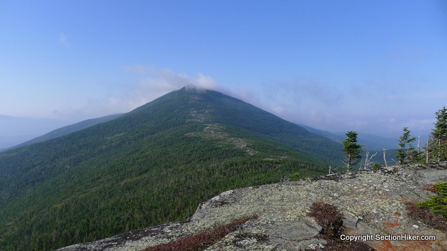
I was out of camp by 6:40 am and headed down the southern shoulder of Spaulding Mountain, a long flat peak called Lone Mountain, before descending 1750 feet to the Oberton Stream. I met another section hiker there, a woman about my age who was solo hiking north up Lone Mountain. We had a short chat, but I was impressed by her determination and pluck!

My goal for the day was to climb Saddleback Junior, the first of the three peaks in the Saddleback Range. From there, I would assess weather conditions and determine whether it was safe to climb The Horn and Saddleback Mountain. There was a campsite just past Saddleback Junior called Reddington Stream, which wasn’t on the 2004 copy of the Maine AT maps I carried, but is listed on the AT Guide pages I carried for this section of trail (Thank You AWOL!). I figured I could hole up there in bad weather if I needed because there was a water source.
But first I had to climb the northern shoulder of the range, called Poplar Ridge, another grueling steep ascent.
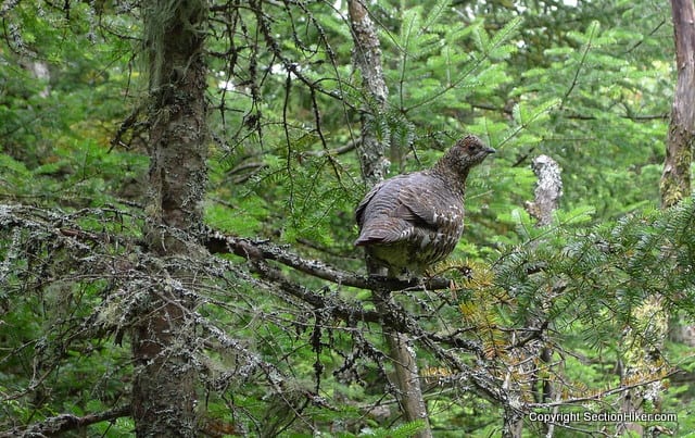
That climb had a silver liner when I saw this Spruce Grouse on the trail. These are the dumbest birds in the world and he let me approach quite close. I last saw a group of these birds down on the New Hampshire AT a few years ago. They are also known as fool grouse or fool hen because they are so trusting of humans.

His camouflage on the ground was pretty remarkable. It was really hard to see that bird until I was almost on top of him, probably good protection from soaring birds of prey like hawks and eagles.
I met my first thru-hikers of the hike at the Poplar Ridge summit, the first of nearly a dozen I’d see that day. The trail was suddenly feeling very crowded. Still, you have to admire these thru-hikers. They fly up the trail, young men and women, carrying huge backpacks. Oh, I wish I hadn’t misspent my youth and I had hiked this trail when I was in my twenties.
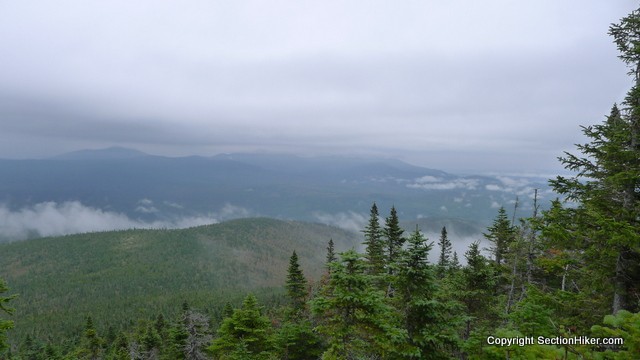
I got a good view of the cloud cover from Poplar Ridge and while the rain was holding off, the cloud ceiling was definitely dropping. I wondered if the upcoming 4,000 footers would be cloaked in cloud. That’s not definitely bad, but it can be if you need to rely on cairns for above treeline navigation in mist.
I soon came to the Poplar Ridge Lean-to where I considered spending the night. Having a roof over my head would be preferable in the event of rainfall. But, it was a dump with a baseball bat floor. This is a floor made out of small saplings the size of baseball bats, which are rather uncomfortable to sleep on. I’ve only seen floors like this in Maine and mainly in very old lean-tos. Most newer ones have flat plank floors.
I was cold and wet from my climb up to the ridge so I heated a pot of water and made strong sweet tea to warm up, using Esbit cubes to heat up my water. The wood around the shelter had been picked clean and what little there was, was too damp to burn. I ate some salami and flour tortillas and got my engine fired up again. I filtered two more liters of water, at the lean-to’s pathetic tannic stream, and headed off, feeling better. Saddleback Junior loomed ahead.
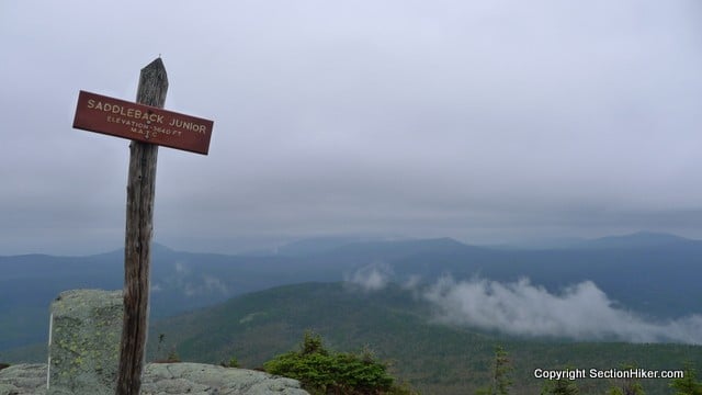
It was cold and windy on Saddleback Junior, so I put on my hard shell and a fleece hat. surprisingly, the summit was fully exposed for about 100 yards despite only being 3600 feet in height. Treeline is closer to 4500 feet down in the Whites in New Hampshire.
The Horn and Saddleback Mountain loomed to the south, two massive mountains which would each require steep ascents. I’d be happy to get over those beasts. It’s hard to imagine the scale of these summits, which are covered in dense forests with miles of separation, even though they’re part of the same ridge.
I descended the other side of Saddleback Junior and soon arrived at the Reddington Stream Campsite. It looked like it had been bombed! I assume this was all flood or storm damage. The campsite has about 8 tent sites, most packed earth, but with two raised platforms. The packed earth sites were curiously situated below down slopes, making for bad pitches on a rainy night in a floorless tarp.

Note to the Reddington Stream Campsite Maintainer: That outhouse pit pile is getting precariously high.
Rain Delay
It was 2 pm when I’d arrived at the Reddington Stream Campsite. Stopping so early in the day is against my nature, but it was that or risk being benighted (hiking after dark) between The Horn and Saddleback Mountain. It would have been a 4 mile hike with close to 1700 feet of elevation gain to cover the distance between the peaks and get down below treeline and relative safety, plus another 2 miles to a good campsite and water supply. I decided to sit tight and hang out.
I ate the rest of my salami and flour tortillas for dinner and went to sleep when it got dark. That evening, we had a violent lightning storm and heavy rain. I slept through most of it. I felt I had made the right call to stay put.

Day 3
When I woke the next morning, the temperature and humidity had soared. Not good because it meant that the afternoon sun would stir up the atmosphere and result in thunderstorms. The temperature climbed to 86 by nightfall.
I could only see a small patch of sky from my campsite, the area of trees cut out above the platform I had pitched my tarp on. The clouds above me were a solid grey but I could make out dark blue rain clouds through the trees to the east. That was a bad sign. I seriously considered taking a zero and staying at the campsite for the entire day to wait out the storm. That was at 6:30 am. I made sweet hot tea but was too agitated to eat much. I think I was afraid of what I might experience if I climbed The Horn.
At 8:00 am the cloud cover started to break up above my tent platform and I saw areas of blue in the passing wisps of cloud. This can mean better weather. The wind was blowing from the northeast though and I had no idea what that meant. I doubted it was very good, since I suspected that the clouds were full of moisture coming off the ocean. I managed to eat two peanut candy bars and decided to climb The Horn to get a better view of the situation. I packed up and broke camp, calming down some as I climbed up the trail.

My legs felt refreshed but the climbing was difficult and required two hands. Treeline started at 3500 feet but it was mostly krummholz, dwarf trees, with some protection from the wind. I could see overcast to the east but no consolidated clouds and no thunderheads. That was a relief. The wind shifted though and started blowing due east over my head. The clouds were wispy with blue patches between them. I had no idea what lay to the north or west though and would have to climb to the summit of The Horn to see what weather was blowing my way. I have seen thunderheads blow toward me at 50 mph on previous hikes from 50 miles away, and been over taken by thunder and lightning above treeline. This shit happens.
I put on my hard-shell and tightened my hat lanyard when I broke out of the krummholz onto the bare rock of the summit. The summit area was crowned in mist and the wind was blowing so hard I couldn’t read the elevation on the summit sign. I pointed my camera and took a picture hoping something would be visible later in the photo.

The cloud cover was intermittent, a good sign. From the summit I could see a bank of consolidated clouds to the north of the summit ridge that was still small enough not to be an immediate threat. Mostly the surrounding valleys and peaks were covered in thick haze. I figured I could make the traverse safely and decided to go for it. I walked fast.
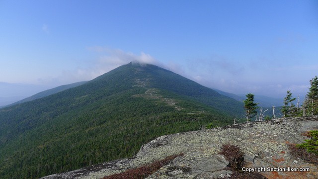
Oh Shit! That’s when I saw how big the next summit was – Saddleback Mountain. It was 1.7 miles away, all above treeline. That’s an impressive distance, comparable to Franconia Ridge down in the White Mountains.
It was blowing, but there were pockets of krummholz between the two peaks that could provide some protection in a dire emergency. However, the cairns on the ridge were fairly small and widely spaced. I’m sure this ridge is a cakewalk in great weather, but traversing it solo in a cloud would be a challenge unless you’re familiar with the route.
I started meeting thru-hikers who had climbed Saddleback from the south and were hiking in the opposite direction. They were dressed in shorts and short-sleeved shirts, while I was all bundled up.
I also met an older peakbagger headed toward The Horn. The first thing he said to me was “Do you think we’ll get thunderstorms today.” Instant recognition of a kindred spirit I guess. I was obviously not a thru-hikers and he looked like a peakbagger. We agreed that there would be thunderstorms later in the day, but that it was unclear how soon they would arrive. He hurried on to bag the peak and hike back down the Saddleback side to his campsite at Piazza Rock Tent Site before the storm hit.

I covered the distance to Saddleback quickly, passing the huge bolts that had been used to hold an old fire tower on top of the peak. Once past the summit sign there was still nearly a mile of above treeline exposure before dropping bag down into the krummholz. I’ll have to come back here in better weather sometime.
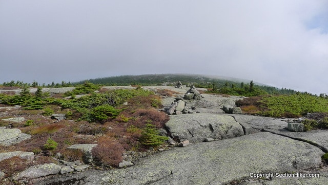
The cloud started to break up as I neared treeline, opening up enough so I could make out Ethel Pond in the valley below. Two days of very powerful thunderstorms arrived later that evening. My caution had been justified.
I filtered some water at Ethel Pond and had a snack, relieved to be down Saddleback. I also inspected my hip which I’d fallen on coming down slippery rocks during the descent. It was pretty bruised up and started to swell. It’s still swollen and tender a few days later.
I decided to hike down to the next shelter, called Piazza Rock, a few miles on and figure out what I was going to for the night. The next few miles of the AT were a gas. This section might be the most root congested stretch of trail, rock, and mud on the trail! I also met two dozen through hikers along the way. They were all emerging from Rangely after resupplying to hike in the warmer weather. I was the only guy hiking south.

I got down to Piazza Rock Shelter which is about 2 miles north of Maine Route 4 and a 9 mile hitch into the town a Rangeley. I sat down at the shelter, which I’d heard was wonderful. Honestly I wasn’t impressed. It’s a small shelter and the surrounding area has been beaten into the ground from overuse. There is no understory vegetation left within a 100 yards of the shelter. I quickly decided I didn’t want to spend the rest of the afternoon or night there.
Based on the temperature change and humidity, I knew we were going to get hit by a big storm system. I wasn’t entirely sure how long it would last but I wasn’t sure I wanted to keep hiking down to Grafton Notch in really bad weather or get stuck under my tarp for 24 hours. Hiking in rain doesn’t bother me, but high winds in big forests do give me pause, together with lightning and flash floods. I’ve been through horrendous crap weather in remote sections of Maine too many times now to get excited about the experience!

I was ready to pull my Section Hiker card and come back in better weather to finish the last stretch of Maine to Grafton Notch. I also knew that a 1 or 2 day delay on this trip would make me miss my wife’s birthday and that would be really bad. Captain Mouse is really cool about my hiking and backpacking trips and has put up with a lot of long absences from me this year without much protest. We had some special plans for her birthday and I didn’t want to disappoint her.
I decided to hitch into town in try to get a shuttle down the Grafton Notch to pick up my car. I got picked up by the first vehicle that I saw on Rt 4. It turned out to be a retired Vet driving into town on business after searching the junkyard in Skowhegan, Maine for a part for his ’31 Olds. Neat guy. We talked about hiking and made small talk about old car restoration for the short drive.
He dropped me off at the super market at the end of town, where I could get finally cell phone service. I started calling all the numbers for the businesses in town listed in the AT Guide asking if they’d run a shuttle for me down to Grafton Notch, basically a 90 minutes drive from Rangeley. It’s not as far-fetched a strategy as you might think – income sources are scarce in western Maine and people will run shuttles on the side for extra cash.
I quickly found a B&B owner who offered me a ride for the price of gas, $8 (the going rate is $100). Is that incredible, or what? I call that Trail Magic. I gave her something extra just because it was the right thing to do. I decided to stay in town that night at her B&B because she was so generous – check out the North County Inn. I plan to bring my wife back to stay there again in Rangeley which is a real nice town to hang out in.

That night, there was a severe thunderstorm just after sunset that lasted all night with 70 mile per hour winds, hail, and lightning. It was so bad it even knocked out the town’s power for a while. I wondered how the thru-hikers out there were and what kind of shelter they’d have for the night. The storm continued into the next day with torrential rain and a 2-day flash flood watch due to so much rainfall. I’m glad I got off the trail when I did.
And that in a nutshell is how I got back to my car in Grafton Notch the next morning. It wasn’t exactly the hike, I’d planned or hoped for, but I’m sure I’ll get back up to Maine eventually to finish those remaining miles between Rangeley and Grafton Notch.
It’s time now to set my sights on the southern states of the Appalachian Trail.
 SectionHiker.com Backpacking Gear Reviews and FAQs
Really enjoyable read. Thanks so much for sharing! Also love the links to other posts, especially Guthook’s on trail magic trash. My wife and I live near the Long Trail in Jonesville/Richmond and have toyed with the idea of providing a cooler with beverages and treats. Now that I think about it more, we will put our energy into something we can be present at and interact with hikers. Just like your trail magic ride to Grafton, our most memorable magic from the PCT last summer involved interacting with locals and helping the trail. How else do you meet cool microbiologist hikers? Trail work with the GMC is in our future as well — cause like you said, it can often outlast feats of urban construction! Great stuff.
Thanks Chris – Guthook has really helped raise the issue of abadoned trail magic and trash on the AT this summer. I think he has a real point. Trail magic is so much better when you receive it from someone in person as an act of kindness like giving a hiker a ride, cooking a meal for them in your home, or letting them use your shower. Being present – I like how you put that.
Great read. Thanks so much. I have a lot to look forward to. When you get back to Rangeley, make sure you visit “Forks in the Air Bistro.” Outstanding and well worth the visit.
I did! $3 Saddleback drafts. I had dinner at the bar. I also recommend the bookstore in town called Books, Lines, and Thinkers.
Nice trip report. Great info on the area that I am happy to hear as I plan my Maine 4000-footers. If you look at the observer comments for Sept 12 on https://www.mountwashington.org/weather/comments/ there is a screenshot of the radar showing the lightning strikes in the area. I assume that’s the big storm you were talking about. You were definitely smart to get off the trail for that. I too hope the thru-hikers were safe during that maelstrom.
That’s it!. NOAA also issued a severe thunderstorm warning for the area at the time. Jule LePage and Judy Dilman are leading a trip that way in a week or two, you might want to tage along.
Also a little tidbit. All of the NOAA weather forecasts for the Saddleback region are “folded” together with the weather out of Berlin, NH, which makes microclimate forecasting for just western Maine very difficult. The innkeeper knew a lot about local weather forecasting.
Yeah, Carl G is doing one in Oct too and unfortunately I’m booked all of those weekends (some with other hiking trips so it’s okay). It’ll be next summer before I’m able to get up to that part of Maine, but I am looking forward to it.
I have never been caught above treeline in a thunderstorm but the thought of it terrifies me. Just being outside in a thunderstorms is scary enough.
This was an excellent report. I remember all of those sections in Maine last year and got so lucky to have beautiful weather 99% of the time. Sometimes we’d forget how tough the trail is in Maine because we’d hiked so much to get there but looking at the pictures now it looks gnarly!!
Excellent post – one of your best. You have a way of bringing the trail experience to life in your descriptions. I also empathize with the feeling of young kids whipping by me on the trail while I pick my way along a steep section ( recently did a training day hike up Monadnock with full pack – passed by college kids on cellphones – yikes).
I hope that means you’ve read the other 1519 posts on this web site!
At least 500…
Wild walking Philip and Maine is so good. You made a good call as that last storm up in the mountains would have been terrible to be in. But Maine has so much to walk outside the AT. Maybe those easy Southern trails can wait.
There are limits to captain mouse’s tolerance of my walkabouts. Got to factor those into my plans, but yes, me and gut hook are scheming some other big adventures.
Maine and “Big Adventure” seem to me made for each other. I am sure you and Ryan will come up with something of suitable to match the “BIG” label, and we look forward to seeing the trip reports.
Great report Phil; Brought back so many memories of mt last AT section (Maine, yup, I’m a LASHER). Sue’s dog, Knucklehead, curled up in my lap late one afternoon after a long hike, just what I needed, a little more heat. Sue provided us shuttles for about 4 days, allowing us to slack-pack through he Carrabasit area. Hike on – Tattoo
What is a LASHER?
Long Ass Section HickER
Spooky meeting a solo NoBo hiker on Lone Mt. Couldn’t help but think of Gerry.
Great reminder of this section of trail that has already flown out of my mind.
Did you happen to think about the missing thru-hiker while hiking this section? Reading about it and knowing this is where she was last seen was a bit haunting.
And seeing that stretch across to Saddleback—man, it did not seem that far when we hiked through. Wow, great visual reminder!
There’s a small shrine to her at the Stratton trailhead, plus there are signs stapled to trees at road crossings. They’ve given up hope of finding her alive. It’s a mystery.
Great post!! I really love the detail that you provide, and always have my AT Guide out and make notes of your highlights. While your writing makes it seem much more daunting, but I am planning on a SoBo thru in 2014, and I appreciate the the dope.
Sydney/TicTac
I did this section last year. It might be my favorite section of the trail. My most memorable moment was sunrise atop Saddleback. I stayed the night at Reddington Stream Campsite and then left in the dark the next morning to get to the summit at sunrise. The views were absolutely outstanding. I even got to see a rainbow from the summit sign!
One of your photos prompted me to ask something I’ve been wondering for a while. What do people do when hiking where there are three-sided shelters. Do you not bring a tent at all, and just rely on the shelter? In the past I’ve been inclinded to bring a tent just in case I don’t make it to a shelter before dark (or if the shelter is full), but that would be a lot of weight that could be saved.
Also, when sleeping in an open shelter, what do you do for insect protection? On one occasion I set up a tent inside the shelter because I didn’t bring any protection, and another time I set up a tent outside the tent because the temperature was warmer than I expected, and figured a depression on the ground near the shelter would be cooler. Both times I felt a little silly because I went through the effort of setting up a tent right next to a perfectly good empty shelter.
That’s a great question – I think I’ll write a post about it. In a nutshell, it depends on your preferences. Some people like the privacy and quiet of a tent. Others will sleep in a shelter if it’s relatively empty. Full shelters can be gross and loud. For bug protection, you bring a head net or bug bivy and hang it from the rafters. You should always bring a shelter of some type with you because some shelters are is poor condition (you wouldn’t want to sleep in them) and it’s first come first serve, so you might not get a spot. I generally carry a very lightweight shelter if I think I might get a shelter spot, but that’s just a hedge.
I hiked that section a few weeks ago, peak bagging. Started at Caribou Pond Rd. and went up Crocker Mountain and North Crocker. Those are some very steep trails overlooking Crocker cirque. The next weekend the GF and I did Sugarloaf Mountain and Spaulding and if anything, those were even steeper. My GF stopped me from walking off a rock slide when the the trail took a sharp right and I didn’t see the trail marker and assumed the trail went straight. I can see how Geraldine Largo may have done the same thing. It is a very steep and rugged trail. I didn’t mind the board across Carabassett stream. It is still there and tied off with a Cable. Probably something the MATC put there? We did Saddleback mountain and the Horn a couple months ago. I didn’t think Piazza Rock shelter was all that bad. Nice area and the MATC volunteer taking care of that section of the trail was a sweetheart.
So how long of a hike is this? I mapped it out and saw about 28 miles. I just want to make sure I’m right about my mapping. I would start this hike just off rt 4 and end on rt 27. I’m thinking this is a two day hike. About 15 miles a day. I would be hiking a little before dawn and right up to sunset. This would be my first official hike and I want a challenge. Thoughts?
I say it’s 32 miles above. You probably want to factor in your elevation gain and some extra time if you’re delayed by thunderstorms. I don’t know when you plan to hike, daylight hours in a day, etc.
Thank you for the reply. I’m shooting for an august hike so I’ll have about 15 hours of daylight. I plan on starting on a Friday afternoon and finishing on a Sunday.
My son and dil (30 yrs old) are thru hikers ( or are they section hikers?). They’re hiking the northern half of the trail now after my dil was injured last year half way along. Anywho… they are on this stretch right now…was great to “follow” them via your recounting…but also pretty scary. I’m hoping they’re learning or have learned much of what you already know? So far so good with great fb pic postings…I do envy them. I’d love be one of the tough old girls who they say they meet regularly…
How was the Orbeton Stream crossing? My map says it’s “dangerous” but I can’t find any info online or in the Maine guide about it.
It wasn’t high when I was there. Nothing was. The streams flash up in heavy rain. Just wait it out.
Very helpful blog post! I’m doing a section hike from Snickers Gap VA to Katahdin and really needed and appreciate your detailed description of the Rangeley to Stratton part of the trail. Thanks.
My Recommendation would be not to hike the AT without your own shelter, tent, tarp, hammock, or bivy. Reasons:
Shelter may be full. Shelter might not be in the best location for your hike, either too close, or maybe too far from where you plan on your destination. Most important: emergency shelter. Let’s say you fell and broke an ankle, leg, or other limb. or maybe just be suffering from a painful strain. You might even be brought to a stand-still because of a bad blister. Add rain. A shelter might well mean the difference between hypothermia and safety, and yes, life and death. Even i summer, the challenge of a rainstorm can be not staying dry, but staying warm. Sometimes the only solution is to get into your own shelter and into a sleeping bag. You might well be a far distance from an AT shelter.
Those are safety reason, but suppose you just want to cover more miles, or just stop by a beautiful stream, on a beautiful day to relax, reflect, write in a journal and just plain camp out at a wonderful spot along the trail, on high ground or in deep woods. Carrying your own lightweight shelter just plain opens up many more options and ways to enjoy your hike and “smell the roses”.
Did you ever get to the next section south f this, specifically Bemis Mountain Road to South Arm Road? (Bemis Mountain, Elephant Mountain, and Old Blue?) If so, I can’t find your write up of it. I was curious on your thoughts of this section. I’ve done it twice and found it unusually tough, even for Maine.
It’s still on my to-do list but I haven’t gotten up there.