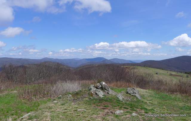
Anyone who says the Virginia doesn’t have rocks is a liar. If I didn’t know better, I’d swear that the stretch of trail from Rt 60 (outside Buena Vista, VA) to Rockfish Gap (outside of Waynesboro) was really in New Hampshire.
Gary, my shuttle driver, picked me at up 10am and took me back to the trail after my Nero (near a zero) day in Buena Vista where I picked up a mail-drop and got cleaned up.
I had planned a short hike into the nearest shelter, so I had him pick me up late in the morning. But I was rested and well fed, and decided to hike to the second shelter, called the Seeley-Woodworth Shelter instead.
Along the way, I climbed magnificent Cole Mountain, which is covered my large swaths of mowed lawn that cover the main peak and its sub-peaks. The area is clearly a local favorite, and I saw many day hikers that day climbing to the top and walking its length.
I’m not sure that Cole Mountain qualifies as a bald, but I was sure glad that I wasn’t up there in a thunderstorm because there is absolutely no cover.

After Cole, the trail stayed up above 3000 feet for another 9 miles with many excellent views of the Blue Ridge mountains to be seen.
I also ran into Pack Mule again. He was resting on the trail, smoking a pipe of loose-leaf tobacco and I took a break to chat with him. He was headed to a campsite a bit farther along, “behind a big rock, next to a spring.”
I hiked ahead and was refilling my water at a spring, next to a huge rock, when Pack Mule caught up with me again. This was the place he’d been hiking too…you have to give the guy credit, he knows the trail.
When I arrived at the Seeley-Woodworth shelter, around 5 pm, there was no one there, and I was afraid I’d have the shelter all to myself. While this is a luxury in some ways, it’s also a lonely way to spend the night.

Luckily, a thru-hiker named California rolled in around 7:00 pm. Technically he’s not a thru-hiker, because he’s only hiking the first half of the trail from Springer to Harper’s Ferry.
California had started the trail on March 1, which was a month or more later some hikers who were just few days ahead of him. An EMT by training, he is in fact from California, but has worked the past two summers taking disadvantaged kids backpacking in the White Mountains of New Hampshire, something, which he plans to do again this year.
After I woke up the next morning, my shelter mate was nowhere to be seen. His stuff was still there, but he had set up the inner fly of his tent about 200 yards away. I never spoke to him after that, but I have to assume that I was snoring that night. Gosh. I really am sorry about that.
Since he wasn’t in the shelter, I was free to make noise without disturbing anyone and packed up to get an early start. I had two big peaks to climb, two 4000 footers, called The Priest and Three Ridges. I’d been hearing about both and they promised to have lots of elevation gain and great views.
I’m not sure why The Priest is called the Priest, but I’d lucked out by climbing the peak from the south on the AT, which only requires about a 1000 foot climb. From the north, the climb is closer to 3000 feet and it is steep and rocky, much like a New Hampshire mountain.
Being the weekend, The Priest also proved to be a very popular destination with local day hikers and backpackers and I must have seen 100 or more struggling to the summit. It was good to see that there’s a strong hiking culture in the area.
When I’d reached the base of The Priest, I stopped to clean the sweat off of my face and dip my hat in Cripple Creek, site of a beautiful waterfall. As I wiped my brow, one of the hikers climbing The Priest, said “Are you Philip Werner?”
I was stunned. That’s when I met Zach from Maryland, who is a Section Hiker reader. He was staying at the nearby Harper’s Creek Shelter on the AT with a friend and had driven down to Virginia to witness “green out”, when the trees sprout their leaves. I’d never heard that term before, but it makes sense.
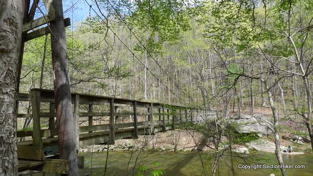
I hiked downhill to the Tye River where I walked over an elegant suspension bridge over the river. I plunked down and had a drink and a rest. I was bonking, but I wanted to get to the Maupin Fields Shelter that night which was still many miles away.
I started up a large 4000 footer called Three Ridges, but it was bad. I was feeling done.
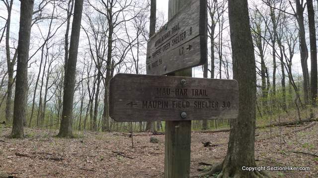
I came to a trail junction for the Mau-Har Trail, that I’d seen on my map the previous evening, which is a blue-blaze spur trail off the AT that links back to it at the Maupin Field Shelter in just 3.0 miles. It provides an alternate route to the shelter, also useful as a bad weather bypass, that halves the distance.
I felt hugely relieved that I only had 3.0 miles (90 minutes at my pace) to get to the shelter and set off with renewed vigor.
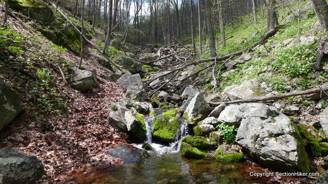
Bad idea. While the Mau-Har provides an alternate route that is shorter, it’s also quite a difficult trail that has the same amount of total elevation gain as the normal route over Three Ridges Mountain, but is far more challenging to walk because it climbs up a steep ravine. Mind you the ravine is quite scenic, with a beautiful waterfall, hillsides covered with blooming flowers, many great swimming holes, and a rushing stream that’s channelled through a narrow gorge just feet away from the trail.

It all worked out in the end I guess, but I was completely zonked when I got to the shelter around 5 pm. I’d been walking nearly 10 hours non-stop.
I set up my Yama Mountain Gear double-walled tarp (a Cirriform DW-1), fetched my 3 liters of camp water, and started cooking dinner on my wood stove.
About then Fitz arrived, a section hiker who was hiking from Harper’s Ferry to Springer Mountain, southbound. He’d hiked the upper half of the AT last year and was determined to finish it, From Vermont, he’d hiked the Long Trail previously, like me, and gotten hooked on backpacking.

He did pass along some bad news though. A major rain storm was forecast to begin the following day, that would dump 1-2″ of rain starting by early afternoon. In other words, a good time to be hanging out in a shelter with a substantial roof over your head.
The storm was forecast to begin at 1:30 pm, so I decided to get up early the next morning and try to get to the next shelter by 2:00 pm, about 16 miles away.
I broke camp the next morning by 7 am, skipped breakfast, and snacked on the trail instead. Basically, I hauled ass, hiking the distance to the Paul C. Wolfe Shelter non-stop and “hurriedly”. The rain started at noon, but it was on and off at the beginning, so I didn’t get soaked.

The reason I was hiking so hard the past few days was that I planned to meet Gen Shimizu from Yama Mountain Gear at this shelter the night before heading off trail for a Nero. Gen lives in Charlottesville, near Waynesboro, which is at the end of this section, and he wanted to “get out of the office” and meet me at the shelter, before hiking out together and driving me into town. A long distance hiker, Gen likes to provide Trail Magic for other hikers passing thru.
Gen arrived at the shelter at about 5:00 pm, still before the big storm started. He’d run in, carrying his gear in a trail-running pack, and wearing sandals.
We’d never met face to face before, so when I saw him, I instantly thought his trail name should be Gazelle. He is a lean train running machine, with little extra body fat. His real trail name is actually Magnet, because he is apparently an animal magnet, attracting all kinds of mammals from cougars, to bears, rampaging ponies, marmots, and skunks.

The Paul C. Wolfe shelter is quite new, so probably the best choice to weather the pending storm. Set high up on a hill and overlooking a stream and waterfall, it was no in any danger of being flooded out if the stream started to flash up due to added water volume,
Red Feather arrived shortly after Gen. She and her husband, a triple crowner had started winter hiking the AT in December! She had to leave the trail for 6 weeks for work, but he continued on without her and was already on Pennsylvania (he’d already hiked half the trail the previous year).
Red Feather is a tall big-boned redheaded woman, with a very obvious Canadian accent. She’d hiked a 30 mile day to get to the shelter and had no idea that the pending massive rain storm was about to hit. I subsequently learned that she is a 4 time Olympic Gold Medalist in speed skating.
The rain started falling lightly as we busied ourselves with dinner preparations. Gen had carried in a pre-soak meal and I ate cold Nutella and tortillas.
I adopted a strategy on this hike to carry a few cold dinners, or the makings of ones, in addition to hot meals, a prudent precaution considering that I was carrying a wood stove on this trip. I had Esbit cubes as a backup for wet weather cooking, and I used them a few times, but sometimes cooking is a hassle and this was definitely one of those times.
The rain started to come down hard by about 7:00 pm as mist filled the gorge where the shelter was located. The mist made the shelter very cold and I put on every single piece of clothing I had to stay warm. Gen, who hadn’t brought much extra clothing, covered himself with his sleeping bag to stay warm.
We sat and talked for a while, but the wind started blowing the rain onto the front porch, so we retreated further into the shelter to stay dry.
By morning the rain stopped, although more thunderstorms with hail were forecast for the afternoon. Red Feather had left before we woke and I never caught up to her afterwards.

Gen and I skipped breakfast and hiked out to his car, about five miles away. There was a ton of water on the trail and the streams were overflowing, so we clowned around at the stream crossings, walking back and forth through the water, which felt good on my feet. Except for rainy days, my feet seldom got wet on this section hike: very different from the Appalachian Trail up north.
Gen proved to me a remarkably cordial host for my Nero. We stopped at Rockfish Outfitters on the way to Waynesboro so I could pick up a new waterproof stuff sack to replace one that had finally shit-the-bed.
After that we swung by the Waynesboro YMCA where I grabbed a free shower, since Gen’s is a little too flaky for guests at the moment. He’s living in his workshop at the moment to provide more capital investment for his business.
Rather than heading for the buffet at Ming’s (best Chinese food on the trail, $8 all you can eat), I had a craving for a large green salad. We stopped at his home/workshop in Charlottesville, and then walked up to Tea Bazaar, a fantastic Tea House on the pedestrian mall.
Further acts of gluttony were committed later that day, along with doing laundry, and breaking up the mail drop that I had sent Gen to hold for me.
To be continued. Hike on.
 SectionHiker.com Backpacking Gear Reviews and FAQs
I did a little digging and found Red Feather’s blog, here’s a post about her first day on the trail: https://clara-hughes.com/the-accidental-thru-hiker-walking-the-appalachian-trail-part-one/
I met Stretch in Harper’s Ferry and we rode the trail to Washington DC together, which is when he told me about Red Feather’s athletic achievements. I guess speed skating prepares you to walk 30 miles days. :-)
Thank you boilerbugle for posting the link to Red Feather/Clara Hughes blog. I’ve been reading some of her blog posts and I may go ahead and order her book, she’s quite an inspiration to me. Women hikers/athletes and mental health advocacy are two things close to my heart…I wish there were more women out there!
It was great meeting up with you on trail and I had a blast clowning around in the water!
Great Post Philip, I think VA compared to PA there isn’t any rocks. The ones in PA seem to jump up all over the place. Keep on keeping on.
Phil,
Thank you for your trail reports in Virginia.
As soon as school is over I was planning Damascus-Buena Vista. I really am looking froward to it.
Gotta ask how are the ticks? From Springer to Damascus, I have been very lucky but use permithin on clothes.
Sounds like you are having a great time!!
Keep on truckin’ my friend
I only saw two land on me and my gear, but I met a couple of local scout troops and the scoutmasters reported finding ticks on their kids. There were surprised at how early the ticks were out. The really tiny nymphs are the most dangerous for Lyme. Be safe.
You’re finally in my backyard. Welcome! I was actually on the trail last weekend in the northern part of the park, first time in several months. Sadly, about 7 weeks ago I moved away from Charlottesville for a job on the Virginia coast and it’s one of those decisions that were it not for some job security, I never would have left. I hope to return at some point for the long haul, but for now, my time on the trail is very limited. I’ve met Gen a handful of times and see him around town and at different outdoor events. Nice guy with good products. Enjoy the trail and scenery in Virginia.
As for rocks on the central Virginia AT, I helped build the 4-mile section west of the Blue Ridge Parkway and north of Reeds Gap in the 80s. It may be the rockiest section in the southern half of the AT.
Hi Philip – I was wondering why you didnt bring along your hammock system for these sections of the Virginia AT? I am planning to hike this section in early fall, and have recently gotten interested in switching to a hammock system (thanks to many of your reviews!). Given you are an otherwise experienced hammocker, was there any particular reason you went with your tent?
Thanks,
Brody
I don’t think I was in my current hammock phase then. I don’t think I’d section the AT without a hammock though, even again.
Thanks Philip. Makes sense