Day 2: Alltbeithe Youth Hostel to Loch Affric
Day 2 : TGO Challenge Route Plan (2010)
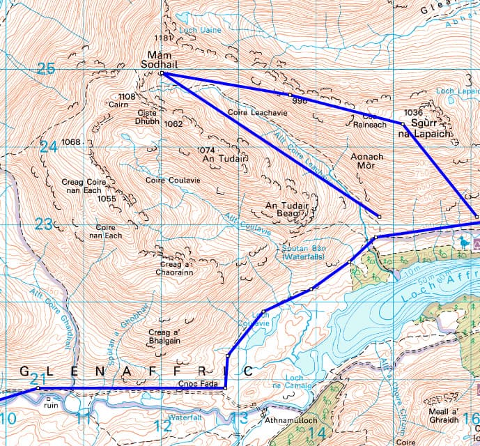
After breaking camp somewhere between Alltbeithe Youth Hostel and Carnach Mor, I continue along the northern side of River Affric passing Allt Coire Ghaidheil (NH108208) and several ruins on the other side of the river, arriving at Cnoc Fada (NH124209) at mile 3. At a trail junction, I head north along a smaller track in the direction of Loch Coulavie (NH132215). The way continues through heather, crossing the Allt Coire Leachavie (NH146228) before flattening off to run along above Loch Affric and through Scots Pines on the shore.
At mile 4.8, I arrive at Allt Coire Leachavie (NH148228). From here, there’s a path that climbs over 1,100 meters to a Munro named Mam Sodhail (1,181m) over 3 miles. That’s steep. A mile or so north of Mam Sodhail is Carn Eige (1,183 m), another great climb. Together these are the two highest peaks north of the Great Glen and have spectacular viewpoints.
I’m guessing that I can make it up Mam Sodhail even in so-so weather it because the path runs up a ravine that will shield me from weather coming from the west until near the summit. If the weather is decent, I’ll continue to Carn Eige. Otherwise I’ll skip it and turn around.
From Carn Eige, there is an option to continue east to two other Munros, but that would make this a full day hike. Instead, I plan on coming down the path I climbed, but making a slight detour on the descent to a subsidiary Top named Sgurr na LaPaich (1,036m). This peak was formerly on the Munro list but taken off. From there, it is a short descent down to the shore of Glen Affric.
The round trip distance for this climbing detour is about 7 miles on top of the 5 miles I will have walked to reach it. If the weather is bad, I’ll skip the ascents and continue on my way to Fort Augustus, about 2 days further southeast where I plan to spend the night in a B&B.
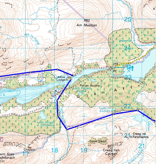
If the weather is good enough for an ascent, I’ll continue along the north short of Loch Affric to Affric Lodge, where there is a bridge crossing (NH185229) to the southern shore. From there, I’ll head east along the southern shore of Loch Affric which is wooded and find a nice place to camp for the night (NH165222).
Written 2010.
SectionHiker never accepts payment for gear reviews or editorial coverage. When you buy through affiliate links on our site, we may earn a small commission at no extra cost to you. Help us continue to test and write unsponsored and independent gear reviews, hiking and backpacking FAQs, and free hiking guides.
This is one to check with the "sage of mountainview". Good looking trail on the way up, but not so clear on the way down (discontinuous traces along the ridgeline) and a lot of scree on the descent. (but then you're used to that) I'm curious as to what you are planning for footwear as lightweight shoes might not be exactly appropriate for this trail.
That is the dilemma I face. Leather boots are not going to cut it in scotland with all of the stream crossings. I'm probably going to end up with a pair of trail shoes. Right now (this very minute), I'm trying Inov8 Roclite 320's to see if they'll work. No ankle support, but a decent stiff last, so I'm hopeful. Most of the other walkers that I'm friends with on the Challenge have successfully made the transition from boots to trail shoes, so I'm optimistic.
If you make it onto Carn Eighe I would recommend continuing along this fine ridge over Tom a' Choinich and descend down the path that follows Allt Toll Easa. The ridge to Sgurr na Lapaich https://www.flickr.com/photos/paulsammonds/2918462… is also a good route off although the descent is quite steep and the route across to the path above Affric is a bit rough.
Paul – your pictures are incredible. Thanks for the extra motivation. This looks like a great extension.
Glad you liked the photo's, I'm sure you were already well motivated.
I'm steadily reading through your route, looks great so far! If you get lucky with the weather and fancy a high camp try Bealach Beag on the col between Carn Eighe and Beinn Fhionnliadh at NH116275. I had a nice grassy pitch here and found water on east side of col in a small burn running down to Coire Lochan.
Hope you enjoy the trip.
Thanks for the camping suggestion and keep them coming! I should be posting week two (Kingussie to Montrose) of my TGO route in the next few days.