Mt Lafayette is the highest peak on Franconia Ridge and the most popular because day hikers and backpackers can stop at the Appalachian Mountain Club’s nearby Greenleaf Hut to refill their water bottles and buy lunch. It can also get very busy on summer weekends with AT Thru-hikers and tourists, but there are routes that you take to climb Mt Lafayette where you won’t see a soul until you get to the summit. Climbing the peak on a weekday or after a holiday weekend is also a great way to avoid the crowds. So is winter, but that’s a very different kind of hiking.
The most popular trails to climb Mount Lafayette are the Old Bridle Path and the Falling Waters Trail. The Old Bridle Path climbs up to the AMC’s Greenleaf Hut. From there people hike up the upper half of Greenleaf Trail to the summit, reversing the route to hike down. You can also hike up the Falling Waters Trail to Haystack Mountain and do an abbreviated Franconia Traverse over Mt Lincoln, before reaching Lafayette, descending via the Greenleaf Trail to the hut and back down the Old Bridle Path.
But the least crowded way to climb Lafayette is to hike up the Skookumchuck Trail to the Garfield Ridge Trail over Northwest Lafayette before reaching Lafayette. Northwest Lafayette is also a 4000 footer, although it’s not on the AMC’s 4000 footer list. From Lafayette, you descend to the hut on the upper half of the Greenleaf Trail, and then continue on its lower half through Eagle Pass. From the bottom, you can follow the Franconia Notch Recreation Path back to your car at the Skookumchuck trailhead. I hiked this route a few weeks ago and saw fewer than a dozen people total on the less popular trail segments.

Trail Sequence
- Skookumchuck Trail: 4.3 miles w/3050′ of elevation gain
- Garfield Ridge Trail: 0.8 miles w/600
- Greenleaf Trail: 2.7 miles w/0′
- Franconia Notch Recreation Path: 2.9 miles w/150′
Note: This is a strenuous hike that’s 11 miles in length and requires 3800′ of elevation gain. The route has significant stretches of above-treeline exposure and should not be attempted when thunderstorms are in the forecast because there’s very little cover once you leave the relative safety of the forest.

Skookumchuck Trail
The Skookumchuck Trailhead is on Rt 3 at the end of the Franconia Notch Recreation Path. It’s a pleasant forested trail to climb with good footing. While you are climbing 3000′ of elevation, the grade is relatively gradual compared to other routes. The footpath is generally soft and covered with forest duff, which is easy on the feet and legs. The top of the Skookumchuck gives way to some minor scrambling as you approach treeline at the trail junction with the Garfield Ridge Trail, but it’s nothing major.
There are quite a few streams along the Skookumchuck, so you don’t have to haul a ton of water with you on the climb. The last reliable one is at the top of Skookumchuck Brook, 2.3 miles up the trail, at 3100′. I’d recommend filtering it. You can also refill your water bottles at the Greenleaf Hut on your descent during the months that it’s open to the public.

What is a Skookumchuck? Wikipedia says it is a Chinook Jargon term in common use in the Pacific Northwest, meaning whitewater or the rapids formed by tidal action. These are fun to surf in a kayak or on a surfboard. The word “Skookumchuck” does get easier to pronounce if you say it a few times. Skookumchuck, Skookumchuck, Skookumchuck.

Garfield Ridge Trail
When you come to the Skookumchuck Trail and Garfield Trail Junction, you want to make a right-hand turn (south) to hike to Mount Lafayette. This section of the trail coincides with the Appalachian Trail and you’re likely to run into thru-hikers between July and September.
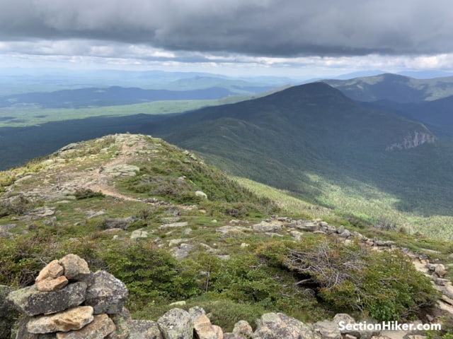
The trail climbs over large rock slabs and boulders from the junction to the summit of Northwest Lafayette before continuing to the Lafayette summit sign. If it’s solitude you seek, Northwest Lafayette is the perfect place to enjoy a picnic lunch, with excellent views into the Pemi as well as the Kinsman Ridge to the west on the other side of Franconia Notch. Truth is, I usually hang out here and blow past the Lafayette summit to escape the crowds (yes crowds) of people who sit all over the summit and hog the summit sign. :-)

The route above treeline is marked by large rock piles called cairns that have been constructed by trail crews. These are much easier to see than painted blazes if cloud cover blankets the summit and they’re still visible in winter, unlike painted blazes when they’re covered with ice and snow. The boundaries of the trail are marked with small stones to encourage people to stay on the path. The grasses and moss above treeline are rare, delicate plants that have a very short growing season and stepping on them is to be avoided because it can damage or kill them. This is also why camping above treeline is prohibited in the White Mountain National Forest.

It’s a very short hike from the top of North Lafayette, which does not have a summit sign, to the summit of Lafayette which does. Don’t get me wrong. The people at the summit sign are quite friendly, but there tend to be a lot of them. The peak is still worth climbing because the views are so fantastic.
To descend Mt Lafayette, look for the large cairn (west facing) that marks the trail down to the Greenleaf Hut. The trail is very rocky on the way down, so take your time descending and admire the view of Mt Lincoln on your left, which is south on the Franconia Ridge Trail.

Treeline is at 4250′ or one thousand feet below the summit. You’ll know you’ve reached it when a wall of bushes (called krummholz, meaning dwarf trees) surrounds you on both sides of the trail. If you’re hiking in cold wind, you’ll immediately understand why getting below treeline provides shelter and a safe haven in stormy conditions.

When you reach the Greenleaf Hut, pop in for more water and to rest your legs. The views can’t be beaten. There are usually baked goods available for sale that have been made by the crew for day visitors. You don’t have to be an Appalachian Mountain Club member to visit or a paying overnight guest. Anyone can walk in for free. Bathrooms are also available

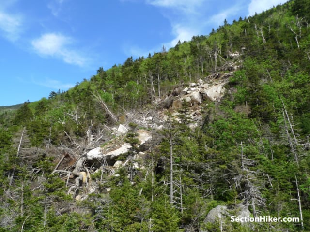
From the hut, look for the Greenleaf Trail sign, not the Old Bridle Path, to descend through Eagle Pass to the Franconia Notch Recreation Path. This section of the Greenleaf Trail is rocky but drops quickly down to the notch. As you approach the bottom, you’ll see a narrow valley between Eagle Cliff Mountain and the northern slope of Lafayette. Avalanche debris can be seen littering the adjacent slopes but they’re not a danger to you. An easy scramble gets you through the pass, followed by a forested stretch down to the Recreation Path. You actually pop out of the woods at the Old Man in the Mountain Wayside off I-93.

Turn right when you reach the paved Recreation Path and follow the signs marked “Bicycle Route” back to the Skookumchuck trailhead parking lot. There are a number of parking lots in between where you can stage a car if you have a companion vehicle or a bicycle, including the New Hampshire Ski Museum lot at the bottom of the Cannon Mountain cable car line. But it’s a fast and nearly level walk back to the Skooumchuck trailhead lot, enabling a solo hike if that is your preference.
 SectionHiker.com Backpacking Gear Reviews and FAQs
When I hiked Franconia Ridge six years ago, I would have loved to keep heading north above tree line along the AT and go down Skookumchuck. However, Gramdma was waiting back at the Lafayette Place campground trailhead for the Falling Waters and Bridle Path trails and would have been rightly incensed had I showed up somewhere else. I would have redlined most of the guidebook trying to find her again!
The Skookumchuck has become my favorite way up to Lafayette . Far more pleasant than the Old Bridle Path or “Falling Bodies”.
PHillip – I took your advise on this beautiful summer Saturday and had the Skook completely to myself!!! Not so much at the top…. The trail was a nice grade. Excellent recommendation!
I have another one for you. I climbed Moosilauke on the Benton Trail today and didn’t see one person until the summit. That’s a little bit more out of the way though. :-)
We LOVED the Skook! Spring a few years ago; needed microspikes for the shady area. And speaking of traction…. Last hike we did we used them, haven’t been to the Whites in 100+ days, waiting for the curve to flatten more. Don’t want to be a Mass$%^& and make folks uncomfortable! Looking forward to better days
I hiked this on 10/11/2021. The hike along Skookumchuck Brook was very pleasant, there was a beautiful grove of birches with bright yellow leaves. Then a long series of stone steps up into the pines. As I neared the top I could see hints of where I was going, with a craggy, rocky peak looming ahead just through the trees. There was only one rock the whole way on which I had to really reach for a handhold – I don’t super love that feeling of insecurity and danger. Lafayette North was stunning, even as the clouds rolled in. The clouds were gone again by the time I got to Greenleaf Hut and so I could sit with a $2 coffee and an apple and stare at that expanse of ridges and ledges in front of me. On the way down Greenleaf Trail there was a great view of Cannon Mountain through the trees. At the bottom, the bike trail back to the trailhead was easy enough to find. Very clearly marked. A thoroughly wonderful fall hike, right on par with the Baldface Circle Trail I did a year ago. Another fun personal touch: I’ve now done every trail up Mt. Lafayette. This loop, and also maybe my having done it in October instead of June, July, or August, is my favorite route.
Starting in 2022 the State is planning to charge for parking in the OBP/FW and Lafayette place lots. Alternate routes to Little Haystack and Lafayette may become more popular then. They haven’t announced how much the parking fee will be, nor if it will be everyday, just weekends May-October, or other.
Old news.