The White Mountains in New Hampshire have a well-deserved reputation as a challenging place to hike. People are always a bit surprised by this because they’re not that high in elevation, only topping out at 6,288 feet on Mt Washington. Still, people come from around the world to train for major international expeditions here because the Whites are so formidable, particularly in winter.
What makes them so tough?
Wind and Weather
Bad weather is certainly a major factor. For example, the average wind speed on top of Mt Washington is 35 miles per hour, the winds on Washington exceed tropical storm force (40 mph) 110 days a year, the summit is covered in clouds 55% of the year, and it snows every month of the year. These mountains deserve respect!
Weatherwise you simply don’t hike in the Whites without carefully assessing the weather beforehand, planning days in advance, and postponing hikes when the weather forecast is bad. When you do get out, you need to be very alert to changes in cloud cover, whiteouts, thunder and lightning, and hail. In cool or wet weather, hypothermia and frostbite are very real risks because the mountain summits are usually 20 degrees cooler than the valleys and the wind accelerates evaporative and convective cooling.

Avalanche Terrain
A lot of people think that avalanche activity in the White Mountains is limited to Tuckerman and Huntington Ravines. That’s just not true. Snow avalanches occur all over the White Mountains in the King, Castle, Burt, and Ammonoosuc Ravines, in Crawford Notch, Franconia Notch, Carter Notch, Eagle Pass, the Pemigewasset, along the Kancamagus Highway, in fact anywhere where there’s a slope angle between 38 and 45 degrees. While Tuckerman and Huntington Ravines are the only places with snow rangers forecast avalanche danger, they occur throughout the White Mountains. Your best defense is to take an avalanche awareness class or avoid avalanche terrain in winter.

Trail Conditions
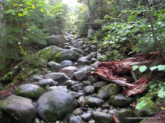
People new to the White Mountains are often surprised by how rugged the trails are. They’re often narrow, steep, and require good scrambling skills to ascend and descend. I know many experienced White Mountains hikers who will tell you that learning how to rock climb vastly improved their hiking footwork.

On top of the roughness of the trails, the ascents in the high peaks are quite steep, rising over 1,000 feet per mile for miles at a time without switchbacks to provide physical or mental relief to weary hikers. The best thing to do under these circumstances is to keep your eyes down (looking up crushes all hope) and take small steps so as not to exhaust your quadriceps muscles.

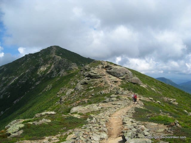
Above treeline trails are also quite exposed to the elements. While these trails are magnificent to hike in fine weather, they can be quite dangerous if the wind or weather turns on you unexpectedly. In an emergency, particularly in winter, the best thing to do is to get below treeline: most people who get below treeline survive to hike another day. Remember, the summit is always optional.
Remoteness
While there are sections of the White Mountains relatively close to major highways, a large portion is quite remote and seldom traveled. I’ve been on hikes in the north country where I haven’t seen people for days. If you decide to venture beyond the well-traveled trails, make sure you hike with others, you are fully equipped, and that you’ve done your trip planning homework. Help is often not readily available and you need to develop a certain level of self-sufficiency if you want to go off the beaten path.

Parting Thoughts
When I started hiking in the White Mountains, they scared me. But there are plenty of opportunities to build your confidence and skill level gradually and safely. If you’re just getting started I recommend that he join a hiking group like the Appalachian Mountain Club. If you’re more experienced, I’d still recommend that you hike with others who are familiar with the territory before branching out on your own. While there are plenty of easy hikes in the Whites, things can go south amazingly quickly, unless you know the territory well and hike prepared.
The White Mountains are a great place to hike and once you get hooked….
See Also:
- Mt Washington Gear List
- Leave No Stragglers: How to Hike the White Mountain 4000 Footers
- The White Mountain Guide and Why It is a MUST-HAVE Planning Reference for Hiking in the White Mountains
 SectionHiker.com Backpacking Gear Reviews and FAQs
rock and ice climbing,and years of hiking in the whites, made my global high expeditions go very well. The whites train you for any weather, and what to carry in your pack. Best training ground ever.
Rockies,Andes, Himalayan Mts expeditions
Nice. I love it here for just that reason. Every hike and backpacking trip is a real adventure. You never know what you’ll encounter.
I’m always reading about how backpackers and hikers claim that the mountains here are small. But relatively many hikes in Colorado or around the world have the same ft in ascent, they’re just located in higher altitudes. Not many people calculate prominence or the location of the trailhead above sea level, unlike in New Hampshire you’re basically starting at 1000 ft or lower above sea level. In Colorado you’re already over a mile up!
…and starting in already thin air!
I have never been more humbled in my life than winter climbing in the whites, topping out in the snowfield above Pinnacle gully with winds challenging your every step makes one realize just how potent the weather can be. I have been gone from my home in Jackson for 17 years and the mountains have been calling me, it is time to return….
Adding to the “Remoteness” section is that in many many places in the White’s – even without going to the northern sections, there is no cell service. It should always go without saying but make sure people know where you’ve gone, your itinerary and when you’re expected back.
Phil – love your comment about keeping your eyes down, so true! Eyes down, small steps and you’ll find yourself on that summit before you realize it.
Also for folks that haven’t hiked up here before, realize that there are a good number of trails that are suggested as ascent only. I pity the person that doesn’t do their research and tries to do a clockwise loop around Liberty/Flume.
LOL: “The best thing to do under these circumstances is to keep your eyes down (looking up crushes all hope) .”
I will say, though, when going uphill on the AT in the mid-Atlantic area where I live I find using Guthook’s “you’re here” function doesn’t “crush all hope” but rather allows my brain to grapple and set expectations with “how much suck is left” regardless of the inevitable false summits my eyes see when I do look up.
YMMV.
A great read about a hiking tragedy in the Whites: ‘Where You’ll Find Me: Risk, Decisions, and the Last Climb of Kate Matrosova’ / https://sectionhiker.com/death-in-the-presidential-range-the-kate-matrosova-incident/
Even better, “The Last Traverse.” Same author.
Thanks for the tip!