Mount Huntington (North) and its three subpeaks, South, West, and East have a notorious reputation in New Hampshire’s off-trail hiking community (North and South are on the NH100 highest list) Dense spruce, blowdowns galore, steep climbs, and sheer cliffs keep most hikers away, since there aren’t any trails that climb these mountains, not even herd paths.
Where are the Huntingtons, you wonder? You’ve driven right past them if you’ve ever driven on the Kancamagus Highway from Lincoln to Conway, NH. They’re located between Hancock Notch and the Kanc, right along the Hancock Notch Trail on the way to the North Hancock and South Hancock Mountains.

Ken and I decided to climb the North, South, and possibly West peaks in late May, in that narrow window of springtime when the snow has mostly melted but the black flies have not yet emerged. The weather was calling for a chance of showers in the afternoon, but we decided to chance a climb anyway and hoped an early start would help us avoid the rain. Bushwhacking in the rain sucks since the wet vegetation quickly soaks your clothing.
We were joined by a third bushwhacker, named Hilde, who we’d met the previous evening at the bunk house that Ken and I stay at when we’re up in the Whites and not camping. An experienced hiker and compass navigator, she’d never bushwhacked in the Whites before and we figured we’d get her started by climbing two of its most difficult peaks!
Ken and I decided to climb the northern peak first before bushwhacking to the south peak, and possibly the west peak. We compared the routes we’d planned and decided to try Ken’s which called for a more westerly approach. Ken’s approach called for hiking up a ridge, making it easier to follow the contour of the land without compasses.

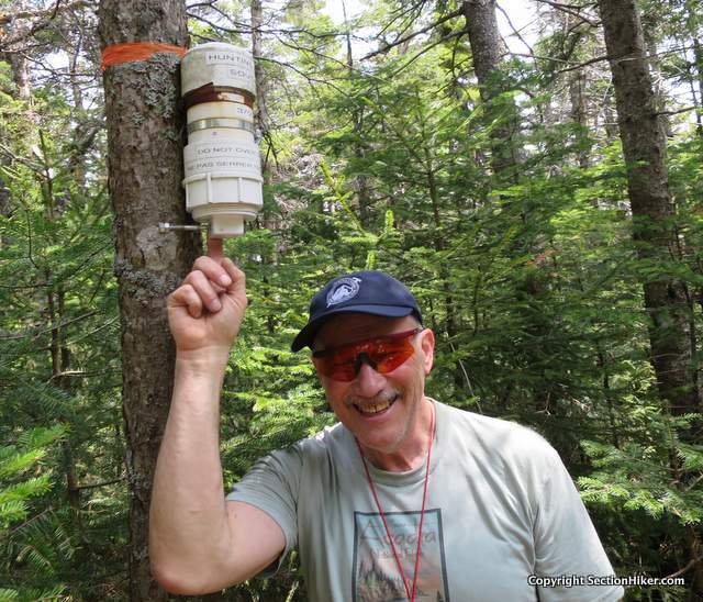
His route turned out to be relatively open, and we made fast time up to the north peak’s summit plateau. But once we got to the top, the vegetation got really thick. Rather than push through, we dropped back down the north side of the peak where it was more open, and circled around until we got closer to the north summit. The final approach to the summit was an easy climb through low-lying shrub and we soon made it to the summit canister (top) where we left a note detailing our route for others to read.
Our next destination was the south peak which required crossing the col between the peaks. Ken had read reports that said this was an easy section, but it turned out to be anything but. Rather than encountering open woods, I had to walk through shoulder high spruce for most of the way, before bashing myself up the other side of the col to the summit.

We nailed the second peak, on target, but couldn’t find the route we’d taken from the north summit when we tried to backtrack. It was lost in a sea of spruce saplings. No worries, I took a compass bearing and we came around the back of the north summit, or so we thought. In order to confirm our position, we climbed back up to the north peak’s canister, and hoped we could recognize the route back from there.
Nothing looked the same. Still we knew where we were, so we dropped down again below the summit and circled back in the direction we’d hiked in, dropping more elevation as we angled back to our starting point. Dead reckoning basically. We knew Ken had nailed the route down when we got back to the Hancock Notch Trail about 50 yards above where we had left it when we’d started our bushwhack.

If it sounds like this was an easy bushwhack, it was certainly a lot easier than Ken and I had expected. The west peak will have to wait for another day though.
Total distance and elevation gain:
- On trail: 3 miles with 450′ of elevation gain
- Off trail: 2.6 miles with 1500′ of elevation gain
- Hike time: 8 hours
 SectionHiker.com Backpacking Gear Reviews and FAQs
when do you plan on hiking the West Peak? That’s the toughest, I hear.
No until the weather gets cooler! Late Autumn at the earliest. The only thing worse than bushwhacking in rain is bushwhacking in high humidity.
There is a rock climb on that face that I’ve been dying to try. A slightly controversial 5.9 I think because of a drilled hold.
You must mean the west peak
Sure. It’s the one that hits you in the face when you descend from the high point of the Kanc heading west. That cliff has always caught my eye. “Southern Migration” I think is the route. https://www.mountainproject.com/v/mount-huntington/106276583
Best decision I made to follow the experts, Philip and Ken, into the thickets described as the worst to be. Dumbest decision not to wear a bushwhack approved longsleeve though I wore my battle scars proudly.
Searching for companion(s) to do the Vose and Peak above the Nubble bushwhacks and several other ones in Maine as listed on the NEHH list.
Thanks Philip and Ken for letting me come along, It was a blast.
Did you ever do the West peak? It was my first pure bushwhack (Vose Spur has herd paths and, sometimes, pink tape). I followed a route from 5/2020 NETC, starting from Hancock Notch Trail where it meets the drainage between West and its sub-peak. No thick woods, just pencils near the summit canisters…one PVC, and an older glass-jar-on-a-rope style!
Never did. But I’m thinking about getting more serious about finishing the NH200 after I finish my second round of redlining, which should be soon. :-0