 SectionHiker.com Backpacking Gear Reviews and FAQs
The Moat Mountain Traverse is a classic White Mountains hiking route that can be hiked year-round. It’s a good early spring hike to do when the high peaks are still snow-covered but the lower elevation trails are starting to clear. But my favorite time to hike this route is in the fall, when the trees in the Mt Washington River Valley and surrounding peaks are ablaze in autumn color. The views from the ridge are exceptional and you can easily see Mt Washington, Mt Chocorua, and the Green Hills on the other side of the Saco River Valley.
A Moat Mountain Traverse is usually hiked from south to north, following the Moat Mountain Trail for 9.7 miles, beginning at the South Moat Mountain Trailhead and ending at the Diana’s Baths Trailhead on West Side Road, near Cathedral Ledge.
- South Moat Mountain (2,770 ft) is reached in 2.7 miles
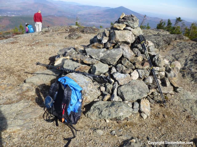
- Middle Moat Mountain (2,800 ft.) is reached in 3.3 miles
- North Moat Mountain (3,196 ft.) in 5.3 miles
The expected duration of the hike is 6.5 hours. You will need to carry all of the water or fluids you need for the entire hike because there are no reliable water sources available until near the end of the route. A substantial portion of the route is above-treeline and fully exposed to the weather, particularly between the summits of South Moat Mountain and North Moat mountain. Depending on the season, be sure to bring a warm clothes and rain gear if bad weather threatens.

Recommended Waterproof Map
Distance and Difficulty Rating
- 9.7 miles with 3250′ of elevation gain
- Moderately strenuous
Trailhead Directions
The Moat Mountain Traverse requires two vehicles, with one at the end to give you a ride back to the start of the route. There is no public transportation available for this purpose.
- To the South Trailhead: From Conway village, drive north on Washington Street and left on Passaconaway Road (which turns into Dugway Rd.). The parking lot and trailhead are on the right side of Dugway Rd. The GPS lat/lon of your destination is 43.99562208, -71.17545359. There is no parking fee.
- To the North Trailhead: The trail head is located on the Upper West Side Road about two and on half miles from North Conway Village. The GPS lat/lon of your destination is44.074656,-71.163048. There is a parking fee. This trailhead can be very crowded on weekends, so plan to arrive early. Illegally parked cars are towed.
On the Trail

The Moat Mountain Trail leaves the left hand side of the parking lot and soon starts climbing through pleasant forest. At 1.3 miles it reaches a viewpoint where you can see the rocky prow-like summit Mt Chocorua on a clear day. Begin climbing the open rock ledges ahead. The path may be difficult to distinguish at times so keep your eye out for blazes. Water seeps down the ledges and they may be slippery, so take care with your footing.

The open South Moat summit is reached at 2.7 miles and provides a welcome wind break on blustery days. Most people take a break here and sit on the rocks to admire the view. The entire Mt Washington Valley can be seen to the west, including North Conway. The mountains on the other side of the valley are called the Green Hills and are home to many fine hiking trails. You should also be able to see Middle Moat and North Moat, to the north, further along the ridge.

Continue heading north along the ridge, following the blazes and rock cairns which mark the route. The trail descends into a patch of trees before ascending to the ledgy summit area of Middle Moat Mountain at 3.3 miles.

Take a moment to gaze back at the pyramid-like cone of South Moat, with its classic profile. The trail ahead descends steeply to the largest col on the ridge. The term “col” is the lowest peak on a mountain ridge between two peaks and is a word you’ll hear frequently used by hikers in the White Mountains.

At 4.2 miles, pass the Red Ridge Trail junction. This trail rivals the Moat Mountain Trail in scenic beauty and is well worth a return visit to hike. See Great Hikes in the Whites: The Red Ridge Loop for a complete trip description.
Climb steeply now up the cone of North Mount Mountain which is the highest of the Moat summits, passing an open shoulder with a fine view. The final ascent to the summit requires a few ledgey scrambles before you reach the large summit cairn.

Mt Washington, the Southern Presidential Ridge and Carter Notch are all visible from the summit of North Moat. Pull out your map and see what other summits you can identify from the 360 views spread before you.
Continuing, descend steeply down the northeast face of North Moat crossing open ledges and passing through scrub. This area can be very slippery in cold weather and requires extra traction for safety. Descend through spruce forest to Lucy Brook and follow the trail beside it, crossing many small creeks and streams over log bridges. The surrounding level area is prone to spring flooding, so follow the trail carefully early in the season before the trail crews can tidy up.
Pass Diana’s baths, a popular waterfall and swimming area (unless you’re ready for a swim or frolic) and continue along a universally accessible trail to the parking lot at the northern terminus of the Moat Mountain Trail.
